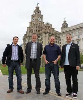
A Knowledge Transfer Partnership (KTP) between Marlan Maritime Technologies Ltd, the National Oceanography Centre (NOC) and the University of Liverpool has achieved an ‘Outstanding’ grade by funding body Innovate UK.
Starting in July 2016, the two-year partnership aimed to successfully build on the existing R&D collaborations between Marlan, the NOC and the University of Liverpool, which previously included a successful European Regional Development Funded project as part of the University’s Centre for Global Eco-Innovation. This project resulted in the successful patenting of a technique which had previously been prototyped by the NOC’s Dr Paul Bell and refined by Marlan’s sponsored researcher Dr Cai Bird during his PhD.
Data innovation
The two-year KTP collaboration involved the NOC’s Dr Paul Bell and KTP Associate Dr Cai Bird working closely with Marlan to develop software and techniques which improve remotely sensed hydrographic data services to the coastal engineering industry. These services enable more cost-effective monitoring, leading to a deeper understanding of the coastal processes and informing better design and building of coastal protection schemes.
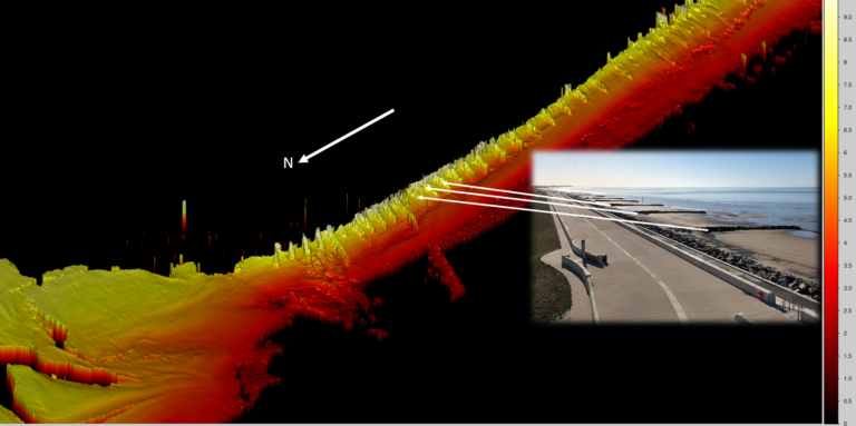
Through the use of shore-based remote sensing platforms, usually a standard navigational radar, Marlan collect data to visualise the location of the ‘waterline’ between wet and dry regions. The rise and fall of the tide, along with the movement of the waterline is then used to create a 3D map of the coastline covered by the tidal ebb and flow. These intertidal areas are particularly difficult to monitor with traditional survey methods and are extremely dynamic in nature. Marlan’s technique, now offered as a data service called Synoptic, allows the user to easily visualise erosion and accretion.
Old ideas, new technology
The inspiration for this technique dates to WWI and the use of aerial photography combined with submarine-measured tidal levels, modernised by the introduction of radars and newly-developed robust software algorithms. Using this method, maps of the intertidal beach areas are generated automatically every few weeks which allow for the monitoring of how coastlines evolve over time. These maps - in combination with radar-derived hydrodynamics such as surface current and wave data - show how and why beaches are changing, providing the vital information needed for the management of key stretches of coastline and erosion hotspots. Until now, the process of undertaking beach surveys has been both challenging and expensive. Surveys were therefore rarely performed routinely and never before at the rate that this system can now achieve.
Wide appeal
The services provided by Marlan appeal widely to over 50 coastal councils across the UK, as well as to a range of sectors in the coastal management industry, including port operators, coastal power stations, sewage treatment works, desalination plants, coastal engineering consultancies and military sites. Currently, the patent covers the whole of Europe, the USA and Australia, meaning that potentially 1.1 million kilometres of coastline can still be considered for future sites.
Alex Sinclair, Managing Director of Marlan commented, “Everyone we talk with is excited at the prospect of having data like this which will provide deeper understanding of the processes acting in complex coastal domains. We are delighted to be providing this information, which is such a valuable tool for protecting people, places and profits in maritime environments.”
‘Gold standard project’
Commenting on the KTP’s achievement of ‘Outstanding’ grade, Mick Card, Knowledge Transfer Adviser for Innovate UK said, “This project sits in the top 20% of all UK Knowledge Transfer Partnerships – it has achieved the “Triple Crown” of transforming a company’s business, Associate career out-performance and highly acclaimed industrial impact for the National Oceanography Centre. A gold standard project in a gold standard programme.”
The NOC’s Dr Paul Bell also commended the collaborative results of the partnership. He said: “I am delighted that our KTP has received an ‘outstanding’ grade from Innovate UK. This is the result of the combined efforts of an extremely dedicated team who are determined to bring this fantastic new remote sensing technology for beach mapping into the commercial sector and make the service available to users and managers of vulnerable coastal areas.”
Looking to the future
Through the success of this collaboration between Marlan, the NOC and the University of Liverpool, Marlan demonstrates their ability to transform research from low technological readiness levels to a functioning operational system in a short space of time. Since the start of the KTP project, Marlan has deployed six operational monitoring systems across the UK, with confirmed orders for three more in just the first quarter of 2019.
Contact Marlan to find out more about Synoptic and how they can work with your business.