The impact of rising sea level on the flood hazard from sea defence overtopping means new coastal schemes need to remain resistant to changing wave and water levels over the next 100 years. The design of new coastal flood defences and the setting of tolerable hazard thresholds requires site-specific information of wave overtopping during storms of varying severity, which are combined with future sea level projections.

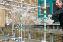
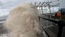
By converting an existing wave measurement technology into an overtopping monitoring system (‘WireWall’), field observations of wave-by-wave overtopping velocity and volumes will be made at our case study site Crosby, in the North West of England. The new system will collect observations that will provide site-specific data to:

  • perform calibration of overtopping tools, e.g., EurOtop;
  • perform validation of flood forecasting systems and overtopping models; and,
  • develop site-specific safety tolerances to inform flood risk response plans.

Recent advances in technology mean existing wave height sensors can now measure at the high frequencies (a few 100Hz) required to obtain overtopping data, making this the ideal time to initiate a step-change in coastal hazard monitoring capabilities. At Crosby a business case for a new sea wall is underway.

Deployments at this site will provide the Coastal Group with the site-specific data and calibrated overtopping tools that they need to design a new, cost-effective seawall. The deployment of WireWall at Crosby will be the first step towards the development of an overtopping monitoring system that could ultimately be integrated into new coastal schemes as part of the UK’s regional coastal monitoring programmes. Such data would enable long-term trend analysis of the changing flood hazard as a consequence of climate change and sea level rise at the coast.

Aim

This project aims to take a low-cost instrument that has previously been used to measure waves in the open ocean, and convert it into a system (‘WireWall’) that will measure coastal overtopping hazard. The system will employ a three-dimensional grid of capacitance wires that detect contact with saltwater. This signal will be used to measure the volume and speed of overtopping at vulnerable locations on the 900-m long sea wall at Crosby in the North West of England. This sea wall is reaching the end of its design life and detailed monitoring of the local conditions has begun to aid the design of a new wall.

When planning sea defences a lot of data are needed to understand the potential hazards that might occur in decades to come. Numerical tools (e.g., EurOtop) use this data to test suitable sea wall designs. The tools do this by estimating the ‘overtopping hazard’ for each design, in other words the volume of water that might come over the wall during storm conditions. Accuracy of the tools is assessed by checking outputs against measurements of overtopping volumes during storms. Field experiments have previously used large tanks placed behind the sea wall to catch the water that comes over. Such experiments are very costly and can be difficult to do, so only a few have been made. They also only provide a limited amount of data and none at all on the speed of the water that overtops: an important factor for public safety. This lack of measurements means there is large uncertainty in the numerical estimates of the hazards, so sea defences are overdesigned to have large safety margins and may therefore cost much more than they need to.

WireWall