Current expeditions
RRS James Cook and RRS Discovery are both currently undergoing refit works. See the expedition pages for more information.
RRS James Cook and Blue Mining
The Blue Mining project is an ambitious €12 million international programme to study processes of formation and preservation of seafloor mineral deposits, and evaluate their resource potential and recovery.
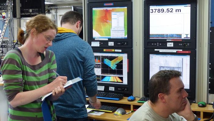
During July and August 2016, expedition JC138 on the RRS James Cook will sail to the Mid-Atlantic Ridge to study a series of seafloor massive sulphide deposits that were formed by hydrothermal activity at a depth of 3,500m below sea-level. The cruise, led by Blue Mining project leader Bramley Murton (NOC), will immediately follow a five week-long site survey cruise on the RV Meteor by our German partners at the research centre Geomar based in Kiel, using autonomous underwater vehicles and near bottom seismic studies.
The RRS James Cook expedition will deploy novel geophysical tools such as active source electromagnetics to get a three-dimensional image of the deposit sub-surface, as well as the robotic underwater vehicle HyBIS to map and sample the seafloor. The majority of the cruise time will be used deploying a robotic sea-floor drilling rig, the RD2, developed by our project partners at the British Geological Survey. The six ton drilling rig will be lowered to the seafloor to a depth of 3,500m where it will drill and recover 50m long cores through the ore deposits, acquire in situ measurements of the sub-seafloor rocks and their properties, and sample fluids from deep within the bore hole.
RRS Discovery and OSNAP
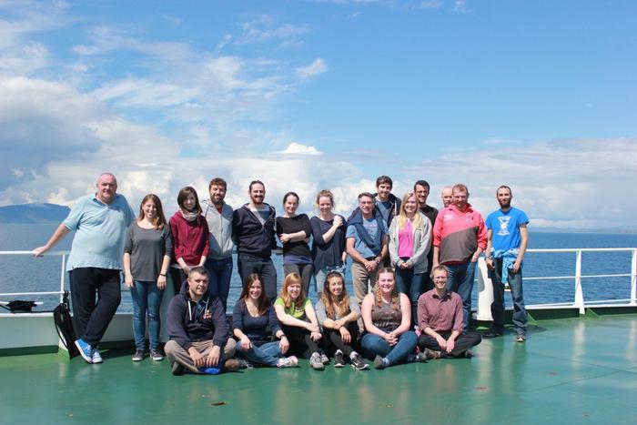
UK-OSNAP is a large project which aims to generate new knowledge and understanding of the North Atlantic Subpolar Gyre and its wider impacts on climate. The project duration is five years and it began on 1st September 2013. It entails activities in ocean measurement, modelling of the ocean and climate, and the analysis of results, requiring significant skills in those fields. Accordingly we assembled a team of experts from around the UK: from the National Oceanography Centre’s two sites in Southampton and Liverpool, from the Scottish Association for Marine Science in Oban, from the Physics and Earth Sciences Departments of the University of Oxford, and from the Department of Earth, Ocean and Ecological Sciences of the University of Liverpool.
This cruise is completing work for the international and UK components of OSNAP. The purpose is to recover and redeploy US moorings in the Iceland Basin (Prof. William Johns, RSMAS) and UK moorings in the Rockall Trough (Prof. Stuart Cunningham, SAMS); deploy Argo floats to sustain the distribution of North Atlantic floats (Jon Turton, UK Met. Office); deploy RAFOS floats targeted to depths of the deep overflows (Dr Amy Bower, WHOI); deploy and recover Seagliders in the Hatton-Rockall Plateau (Prof. Mark Inall, SAMS); deploy and recover Spray gliders in the Iceland Basin (Prof. Dalei Song, Ocean University China). Standard CTD-LADCP sections will be occupied and routine shipboard observations of underway meteorology, sea-surface properties and ocean currents will be monitored.
Read more on their blog and follow @UK_OSNAP on Twitter.
RRS James Cook and DEEPLINKS
In the deep-sea (>200m) the bathyal region of the continental slope has been identified as an area where the rate of origination of new species is high. The reasons for this are not clear, but key to its understanding lies in understanding how populations are connected and if and how they become isolated. The aim of this NERC funded project is to elucidate patterns of population connectivity in the deep-sea utilising realised gene flow and larval dispersal models, coupled with analysis of community-scale patterns.
The #JC136 expedition will focus on an area of the UKs deep-sea, west of Scotland. The aims of the expedition will be to obtain physical samples of selected animal species for molecular analysis, benthic biological survey data for community level analysis, and a small amount of oceanographic data to validate oceanographic models.
The expedition team will use the remotely operated vehicle Isis (ROV Isis) to collect samples of test species from 6 key study sites and from four depth horizons (500m or summit depth, 1,000m, 1,500m, 2,000m). They will then use a type of DNA fingerprinting to look at how closely related individuals of the same species are from populations at different sites and at different depths.These analyses will show how well connected the populations are.
Another part of the project will model the dispersal of larvae from the 6 sites in order to gain a mechanistic understanding of population connectivity and to see if this agrees with the genetic understanding. Another aim of the expedition will therefore be to deploy moorings at the Anton Dohrn Seamount (one of the project study sites) to measure ocean currents at different depths to provide real data to check the ocean current models against.
Finally, the autonomous underwater vehicle Autosub6000 will be used to gather information on the benthic communities at each of the study sites. The expedition team are interested in asking whether sites that are more closely connected by ocean currents have more similar communities of species living on them, and if the degree of community similarity varies with depth.
This research not only has important implications for our understanding of population dynamics in the marine environment, it also has important implications for the future sustainable management of the marine environment because understanding how populations are connected helps us design better networks of protected areas.
RRS Discovery and the Extended Ellett Line
The 2016 annual Extended Ellet Line expedition.
The Extended Ellett Line is a hydrographic section between Iceland and Scotland that is occupied annually by scientists from the National Oceanography Centre (NOC) and the Scottish Association for Marine Science (SAMS), UK.
The measurement programme began as a seasonally-occupied hydrographic section in the Rockall Trough in 1975, building on early surface observations made underway from ocean weather ships.
In 1996 the section was extended to Iceland, sampling three basins: the Rockall Trough, the Hatton-Rockall Basin and the Iceland Basin. These three basins form the main routes though which warm saline Atlantic water flows northwards into the Nordic Seas and Arctic Ocean. The section crosses the eastern North Atlantic subpolar gyre; as well as the net northward flow there is a large recirculation of the upper layers as part of the wind-driven gyre.
During its passage through the region, the warm saline water is subjected to significant modification by exchange of heat and freshwater with the atmosphere. The two deep basins (Rockall Trough and Iceland Basin) contain southward flowing dense northern overflow waters, and Labrador Sea Water in the intermediate layers.
RRS Discovery and the novel trial
#DY051 will visit Goban Spur and Porcupine Seabight, as well as the Rockall Trough, to trial a novel, pressure-coring, experimentation and cultivation system that enables studies of deep-sea prokaryote biodiversity and ecosystem functioning, under ambient or manipulated pressure, temperature and oxygen conditions from any medium sized ocean going research ship with deep-sea coring capability. The MAC-EXP system, developed through a NERC technology development grant, will provide a flexible, cost-effective alternative to in situ experimentation aiming to study the diversity and function of deep-sea prokaryote communities, in particular at the continental margins.
The main aim of the cruise is two-fold:
- To investigate the pressure dependence of microbial DOC and POC turnover in deep-sea sediments via stable and radio-isotope tracing experiments (ITEs);
- To investigate the natural capacity for hydrocarbon degradation in deep sea sediments West off Shetland, and identify the microorganisms involved and their susceptibility to pressure.
RRS Discovery celebrates 30 years at the PAP Observatory
Expedition #DY050 supports the sustained observatory at the PAP site: continuing the observations of the oceanography at this location in the sub-polar gyre and the processes which occur there. A crucial part of the cruise is to recover the moorings which comprise the observatory and which were deployed in June 2015 and to deploy a new set of moorings. In addition to this, scientists from across Europe who have expertise in water column and benthic biology and biogeochemistry will make observations which complement the data obtained by the observatory and which cannot be made autonomously such as rate processes (eg primary production, zooplankton feeling etc) and sampling which cannot be done autonomously such as benthic trawling and coring.
Further information about PAP and PAP Blog.
RRS James Cook and the transatlantic fluxes of Saharan dust
DUSTTRAFFIC is a project to monitor and sample Saharan dust that is being blown from Northwest African sources across the Atlantic Ocean. In particular, the marine environmental effects of deposition of mineral dust on the ocean surface.
To this end, a Transatlantic array of moorings (N = 5) was deployed along the 12th parallel between 23°W (just South of the Cape Verde Islands) and 57°W (just East of Barbados) for the first time in 2012. These stations were re-visited during consecutive cruises in 2013 and 2015.
Each of the moorings contains a set of instruments that are measuring/logging oceanographic properties like Temperature, Salinity, currents, etc., as well as collecting material –both mineral dust as well as plankton remains— settling through the water column. Automated sediment collection is being done using two sediment traps at 1,200 and 3,500m water depth, at a two-weekly resolution. In addition, two moored surface buoys were added in 2014 to the stations at 38°W and 49°W. With these buoys, Saharan dust is sampled from the atmosphere in sync with the material that is collected from the water column.
During RRS James Cook expedition #JC134 – DUSTTRAFFIC IV, five sediment-trap moorings and two dust-collecting buoys will be recovered and two moorings and two buoys will be re-deployed at two positions along the 12th parallel, this time between 23°W and 38°W (East of the Mid Atlantic Ridge). In addition, a third dust-collecting buoy, which is located at 21°N/21°W (off Cape Blanc, Mauritania) will also be recovered, serviced, and re-deployed.
On board, the DUSTTRAFFIC team will collect mineral dust from the atmosphere to be analysed for its mineralogical, chemical, organic geochemical, and physical properties as well as microbiological content. In addition, they will carry out incubation experiments with in-situ collected surface-ocean water with different kinds of Saharan dust. Finally, they will bring different scientific instruments to measure optical- and radiative properties of mineral dust in the atmosphere.
More information on the cruise blog.
RRS James Cook and volatile recycling at the Lesser Antilles Arc
Everyone has probably heard of the water cycle at the Earth’s surface, where the exchange happens between the sea and the atmosphere via evaporation, cloud formation and rain. However, there is also a water cycle within the Earth, where the exchange happens between the sea and the solid Earth. The most important step in this lesser-known cycle is when water trapped in the oceanic crust is returned to the deep interior at subduction zones as part of the plate tectonic cycle. As the sinking plate heats up and gets squeezed a large fraction of the incoming water is "sweated off" and added to the overlying mantle where it causes melting. These melts feed volcanoes above which are dangerously explosive. This activity, combined with the earthquakes triggered by the plates scraping past each other and the consequent tsunamis and landslides, makes subduction zones the most hazardous places on Earth. Yet these regions also have benefits: the cocktail of fluids travelling with the melts concentrates valuable metal deposits and the fine ash erupted by the explosive volcanoes produces nutrient-rich, fertile soils.
The aim of the NERC VOILA (Volatile cycling in the Lesser Antilles arc) research programme is to take a holistic approach to the cycling of volatiles (water, along with other volatiles such as carbon dioxide and sulphur) into the deep Earth at the Lesser Antilles subduction zone. Here the North American plate, soaked with water from the Atlantic Ocean subducts beneath the Caribbean plate. The project combines a range of Earth scientists with skills in petrology, geochemistry, numerical modelling as well as marine geophysics to track the passage of the water as it goes into and out of the subduction zone system.
Expedition #JC133 contributes to Work Package 2: Water Pathways from the Slab to the Arc of the VOILA programme. During March 2016 the expedition will lay out an array of seismometers on the seabed to record distant earthquakes in order to image the wedge (area between the top of the underlying subducting slab and the seabed). They will use methods similar to medical X-ray imaging to determine the seismic velocity and attenuation structure and hence the pathways of the water and melt. The seismic array will also record local earthquakes from the scraping of the North American and Caribbean plates which will help regional hazard assessment and answer specific questions such as is there a link between the fluid pathways and the pattern of earthquakes?
The VOILA passive array is the largest of its type ever deployed at an Atlantic subduction zone. The instruments will sit on the seabed for about 15 months, when another expedition will return to pick them (and their precious data recordings) up. The VOILA team will then conduct further geophysical measurements to determine the pattern of water on the incoming plate in order to complete our understanding of this interior water cycle.
Further information about the cruise.
RRS James Cook at the mid-ocean ridge
The objectives of #JC132 are to acquire the necessary geophysical data to test the very different, often contrasting, hypotheses for the spatial and temporal evolution of oceanic core complexes (OCC’s). These were believed to be the unroofed plutonic and partially serpentinised mantle footwalls of large-offset normal “detachment” faults, structures apparently responsible for accommodating a significant proportion of the plate separation. Following the passive recording of microearthquakes from the active faults using 25 ocean bottom seismographs (OBS) deployed on #JC102 and recovered on #JC109, the primary objective of #JC132 during January 2016 is to collect active source geophysical data (multichannel seismic reflection (MCS) profiles and wide-angle data using OBS) across, between and around oceanic core complexes in the vicinity of 13° 20 ́N on the Mid-Atlantic Ridge. At the same time, high-resolution, near-seabed magnetic and micro-bathymetry imaging will determine spreading history. It is also hoped that gravity and swath bathymetry data will also be acquired port to port.
Further information can be found in the news and blog and another blog!
RRS Discovery and RAGNARoCC
After six weeks at sea the RAPID expedition on board the RRS Discovery is now complete [December 2015]. During this time two hundred and thirty four instruments were recovered and re-deployed on twenty three moorings and landers from the continental slope of Africa to the coast of the Bahamas. Innovative new biogeochemical sensors were successfully deployed for the first time. It is not too late to enter the RAPID Challenge competition to predict the data values collected during this expedition.
On arrival in the Bahamas there was a quick change over of scientists and technicians before Discovery began retracing her steps as part of the NERC Greenhouse Gas programme, RAGNARoCC. This project will complete a full hydrographic survey across 26°N in order to investigate the amount and variability of sources and sinks of greenhouse gases. Follow their progress on the expedition blog or watch a video in which NOC Scientist Dr Brian King introduces the science and objectives of this collaborative project.
RRS James Cook sails to the Atlantic to drill the Earth’s mantle
An international team of scientists set sail on the RRS James Cook to drill through the Earth’s mantle in the centre of the Atlantic Ocean. They left Southampton on 26 of October 2015 to explore the Atlantis Massif, a 4,000 metre high underwater mountain.
This is the first time a UK research ship will be used for this branch of science. The expedition is conducted by the European Consortium for Ocean Research Drilling (ECORD) as part of the International Ocean Discovery Program (IODP). Usually ocean drilling is conducted using specialist drill ships to access the Earth’s deeper rocks. Two state-of-the-art robot drills will be controlled remotely by the scientists and engineers on the RRS James Cook.
During the six-week expedition the team plan to drill at 11 sites in water depths of 720 to 1,770 metres and recover cores between 50 and 70 metres in length.
“Scientifically the sea bed is remarkable because the Atlantis Massif is made up of rocks from the Earth’s mantle”, says marine geologist Gretchen Früh-Green. “In the presence of seawater, these rocks produce methane, hydrogen and heat.” Such rock reactions excite scientists because they represent possible sources to fuel life in the absence of sunlight and may be analogous to conditions found on other planets, or early in Earth’s history.
“Among other things we hope to learn more about what kind of life exists on and within rocks at the Atlantis Massif”, says marine microbiologist Beth Orcutt. “Moreover we shall investigate the fate of carbon. Do the reactions between rocks and seawater lead to carbon storage in the seafloor? And does this process impact the global carbon cycle and our climate?”
NOC’s National Marine Facilities Programme Manager, Colin Day said: “In the 20 years we have been here, it is one of the biggest mobilisations that NOC has undertaken from Southampton. Logistically, there has been months of planning but just getting the ship prepared has taken ten days – there is an extraordinary amount of specialist kit on board the Cook. We are really pleased to be able to support such an exciting and literally, ground-breaking event.”
The two rock drills installed on the RRS James Cook are operated by the British Geological Survey and MARUM, the Center for Marine Environmental Sciences in Bremen, Germany. It is the first expedition of this kind to use this type of remotely operated drilling technology.
The BGS RD2 is the latest generation of remotely operated subsea drills. This drill utilises a wireline coring system and multiple core barrels and drill rods to continuously core in varying types of marine sediments and rock up to 50m below the seabed in water depths ranging to 4,000 m and obtain core with a diameter of 61mm. This drill is lowered to the seabed on an umbilical and once landed is decoupled from the ships motion allowing high quality cores to be collected. The drill is controlled remotely from the surface mother ship through the transmission of power and communications down the umbilical. An optical, acoustic and spectral gamma downhole has been developed to log the hole after coring.
The MARUM-MeBo drill rig is capable of sampling soft sediments and hard rocks down to 80 metres at the sea floor with a total core length of more than 70 metres. It can be operated in water depths up to 2000 metres. It is a portable drill rig which is remotely operated from the vessel. A steel armoured umbilical is used to lower the MARUM-MeBo70 to the seabed. Copper wires and fibre optics in the umbilical are used for energy supply and for communication.
In addition the ship has been built to meet the ICES Cooperative Research Report no. 209 – Underwater Noise of Research Vessels, so called ICES 209 standard, meaning she is one of the quietest research vessels currently afloat.
The RRS James Cook is built with a Dynamic Positioning (DP) system, enabling the ship to deploy large instruments and hold station in all but the most violent weather. There are berths for 32 researchers and 22 officers and crew. Her overall length: 89.2 metres with a beam of 18.6 metres.
The UK’s involvement in the IODP expeditions is funded by the Natural Environment Research Council.
RRS Discovery travels to the sub-tropics to help forecast UK weather
To improve long-term understanding of weather and global environmental change, the Royal Research Ship Discovery left Southampton on the 16th of October for a six week expedition to the Bahamas. A team of NOC scientists are on board to update and acquire data from an array of instruments in the ocean, between the west coast of Africa and the east coast of the USA. Currently data from these instruments is gathered once every 18 months by a research ship. This data is fed into models of the ocean and the atmosphere that help make long-term forecasts of weather and climate.
Using an improved understanding of the AMOC enabled by the decade long RAPID data set, scientists have been making predictions about the data that will be retrieved from Discovery’s expedition. You can see their estimates on the RAPID Challenge Blog where updates on progress of the cruise will also be published.
RRS James Cook to explore deep-sea canyon with new robotic technology
On 9 August 2015, RRS James Cook will set sail for a five-week expedition in the NE Atlantic, led by NOC scientist Dr Veerle Huvenne. This will be the first-ever British expedition to simultaneously use three different types of deep-submergence robotic vehicles. The Autonomous Underwater Vehicle (AUV) Autosub6000 and the Remotely Operated Vehicle (ROV) Isis, both from the MARS fleet at the National Oceanography Centre, Southampton, will be joined by an underwater Seaglider from University of East Anglia. Together the vehicles will be used to characterise the seabed habitats and water column structure of a giant deep-sea canyon.
The main target area is Whittard Canyon, one of the largest submarine canyon systems along the Celtic Margin. It extends from 200m to more than 4,000m water depth, in places cutting more than 1,000m into the continental margin. Submarine canyons are the main transport pathways between the shelf and the deep sea, and are often considered biodiversity hotspots. The complex environment and associated current patterns create a wide range of different niches, each of which attracts specific species. Producing ‘habitat maps’ of the seafloor environment is key to understanding these species distributions.
The steep walls of submarine canyons present a particular challenge for habitat mappers, but are of particular importance as they often host the richest fauna, including vibrant cold-water coral communities. The near-vertical (and sometimes overhanging) rocky terrain means that traditional ‘over-the-side’ equipment, such as grab samplers, sediment corers and towed video frames lowered from the ship, often struggle to provide reliable data. After an initial test in Whittard Canyon in 2009 using ROV Isis, Autosub6000 has now been adapted to become the first AUV to be able to create acoustic maps of vertical cliffs in the deep ocean. The science team will also use Autosub6000 and Isis to collect samples, video and photographs of the seabed, and make acoustic maps throughout the canyon, so that 3D habitat maps can be produced.
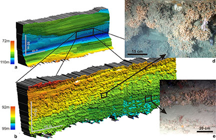
In addition, a Seaglider provided by University of East Anglia will be deployed to measure physical properties of the water column (e.g., temperature, salinity, turbidity), during a 25-day programme of vertical profiling strategically planned at several locations within Whittard Canyon. The results will provide information on water column structure and variability throughout the canyon, and on currents caused by internal waves and tides. It has been shown that these have an important impact on the seabed fauna, supplying food particles and preventing species such as cold-water corals from being draped in sediment.
The easternmost branch of Whittard Canyon is a new Marine Conservation Zone, and is the only deep-water marine protected area in English waters. The expedition is therefore being co-funded by Defra to collect additional data from this site to inform their future management measures, such as potential restrictions on activities that damage the seafloor. The expedition will also feature a return visit to the Haig Fras Special Area of Conservation west of Cornwall, to repeat map an area of seafloor with Autosub6000. This site was first mapped and imaged in 2012 – by repeat mapping the site three years later, potential changes to seafloor habitats and faunal distributions can be assessed. This work is being co-ordinated by Prof Russell Wynn of NOC, and will inform Defra about the potential for marine robotic vehicles to undertake future mapping and monitoring of marine protected areas.
Finally, at the end of the expedition, the team will test another piece of novel technology: a vibrocoring system for ROV Isis. It is currently impossible to obtain good-quality cores of seafloor sediments in some deep-sea environments, due to the sandy nature of the seabed. The new vibrocorer is designed to penetrate these sandy sediments, and having the opportunity to test it in some of the sandy deposits in Whittard Canyon is an exciting prospect as it has potential to increase our understanding of sediment transport processes through the canyon.
The expedition is primarily funded through the ERC Starting Grant project CODEMAP (COmplex Deep-sea Environments: Mapping habitat heterogeneity As Proxy for biodiversity), with support from the NERC MAREMAP programme. The expedition blog is at https://codemap2015.wordpress.com and updates can be received via Twitter @codemap2015.
RRS Discovery expedition to the PAP Observatory
RRS Discovery will be leaving Liverpool on Saturday, 20 June to service the PAP observatory. A full compliment of scientists, technicians and crew lead by Professor Richard Lampitt are setting out to recover and redeploy the PAP moorings, as well as measure a full suite of supporting data.
Lisa Marsh from BODC will be blogging about on the cruise at https://papobservatory.wordpress.com
You can also follow the cruise on Twitter at @PAP_observatory and with the hashtags #DY032 and #PAPobservatory
Exploring the Shelf Seas – RRS Discovery expeditions
Scientists from the National Oceanography Centre (NOC) are among a team on board the RRS Discovery carrying out research as part of the NERC-funded Shelf Sea Biogeochemistry research programme.
The research vessel sailed from Southampton on Sunday 1 March for a 25 day expedition heading to the Celtic Sea. Led by the Plymouth Marine Laboratory, it is the second benthic cruise in the programme, investigating the autumn algal bloom.
Read the live blog written by Louis Byrne NOC.
Following this research cruise, the RRS Discovery will then set sail for a month-long Shelf Sea mission on 1 April. Led by scientists at NOC, it is the second pelagic expedition in the programme and will be looking for the spring algal bloom using satellite images.
Updates and photos can be found on the programme’s Facebook page.
More details on this expedition to follow.
The Shelf Sea Biogeochemistry research programme aims to understand the nutrient and carbon cycling within the shelf seas and their overall role in global biogeochemical cycles. It consists of seven core cruises to the marine shelf (and shelf-edge) of the Celtic Sea on board RRS Discovery. These cruises will focus on the physics and biogeochemistry of the benthic and pelagic zones of the water column during the course of an annual seasonally-moderated phytoplankton bloom.
The research activities include coring, Conductivity Temperature and Depth (CTD) deployments, Acoustic Doppler Current Profilers (ADCP) surveys, moorings and wire-walker deployments, benthic lander observatories, autonomous gliders and autonomous underwater vehicle (AUV) surveys, Marine Snow Catcher particulate matter analysis, plankton net hauls, in-situ sediment flume investigations and laboratory incubations with core and sea water samples.
Collecting Particle Samples in Antarctica
A team of NOC scientists are on board the RRS James Clark Ross on a month-long research cruise to Antarctica, led by the British Antarctic Survey (BAS).
The research ship sailed from Punta Arenas in Chile in early November with the NOC focus being on the carbon biological pump addressing how and why particles sink. This will involve photographing snow particles in situ before collecting them using the marine snow catcher and examining them using microscopes and oxygen electrodes.
The work will take place throughout the Scotia Sea with a particular focus on the high chlorophyll waters around South Georgia.
Read the live blog written by Anna Mikis who is a PhD student on board the ship.
RSS Discovery in the Celtic Sea
The newest NOC research ship, RRS Discovery, sailed from Falmouth in early November on a 23 day cruise as part of the NERC-funded Shelf Sea Biogeochemistry research programme.
Scientists from NOC are looking at phytoplankton production in the Celtic Sea and the role of the shelf sea system in carbon and nutrient cycling.
During the cruise to the Celtic Sea, they will measure the rates at which phytoplankton incorporate nutrients and carbon into their cells, and study how the combined activity of this biological and chemical system influences the cycling of the major elements in the ocean. NOC scientists are also examining the physical oceanography of the Celtic Sea using underwater gliders and moored instruments in order to determine the role of physical processes in shelf sea biogechemistry.
The cruise is being led by Professor Jonathan Sharples from the University of Liverpool / National Oceanography Centre. Follow his live blog.
‘Slides in the Deep’ expedition blog now live
A team of UK scientists is sailing to the site of prehistoric underwater landslides near the Arctic Circle. They are posting their daily reports on a daily blog.
The scientists are aboard the Dutch research ship RV Pelagia to investigate massive submarine landslides that have occurred in the Greenland and Norwegian Seas. Landslide events within the ocean can be far larger than those on land and can generate damaging tsunami.
Scientists from a UK consortium led by the National Oceanography Centre that includes the British Geological Survey and the universities of Aberdeen, Cambridge, Dundee, Exeter, Manchester, Southampton, Ulster and Imperial College will be collecting sediment cores from the deposits of submarine landslides.
Around 8,200 years ago the Storegga Landslide off the coast of Norway moved a huge mass of material equivalent to burying an area the size of Scotland under 260ft of sediment. It is thought to have generated a tsunami that inundated Mesolithic human settlements living at that time on the Dogger Bank in the North Sea.
Dr Pete Talling who is leading the expedition explains “These sediment cores will help us to estimate the emplacement ages of large submarine landslides and the frequency of such events, thus providing important evidence to assess tsunami risks to the UK. It will also help to reconstruct landslide emplacement processes and hence the magnitude of resulting tsunamis.”
There is a photo stream available at www.pinterest.com/millie0692/arctic-landslide-tsunami-project-pe391-cruise.
Follow the team on twitter at #ArcticSlides.
The RRS James Cook left NOC in Southampton on its latest expedition – 18th July 2014
The research ship is heading to the Celtic and Irish seas, the northern approaches to the Barra Fan and the north west and western Irish shelf and is returning at the end of August 2014.
Find out more on the expedition blog.
Meteor Cruise 108 to the Porcupine Abyssal Plain (PAP) sustained observatory
Reports from the PAP Observatory Expedition – July 2014
The latest research expedition to the PAP Sustained Observatory in the North Atlantic is taking place, with scientists from the National Oceanography Centre among an international team on board the RV Meteor. The team are retrieving valuable sediment samples and time-lapse data from instruments submerged in the deep ocean, as well as looking to find out more about ‘marine snow’ – particles of dead material that sink to the ocean floor.
Located in the Porcupine Abyss Plain – the nearest deep ocean to the UK – the PAP Sustained Observatory provides key time-series datasets for analysing the effect of climate change on the open ocean and deep-sea ecosystems.
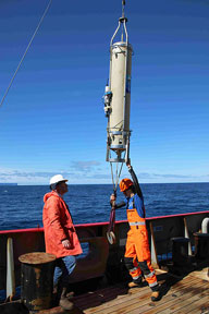
Researchers are deploying the main observatory PAP1 buoy, which has undergone a number of improvements in recent months after drifting free from its moorings in the bad storms last winter. It now features an improved frame and new instrumentation sensors.
The team are also retrieving and replacing deep-sea cameras which have been recording valuable time-lapse data and recovering sediment traps.
The cruise left from Tenerife on Sunday 6 July and is returning to Southampton at the end of month.
Track the team’s progress with live updates from the ship by Professor Richard Lampitt, biogeochemist at NOC.