


A marine heatwave (MHW) — a prolonged period of unusually warm sea surface temperatures — has been intensifying around the UK’s coastline since late 2024. As of 30th April 2025, most UK waters are experiencing a Category II MHW), with sea surface temperatures up to 3°C above the seasonal average.
As the current MHW is occurring before the height of summer, it is unlikely to reach temperatures that would cause major harm or mortality to marine species, but what are the potential impacts? Dr. Zoe Jacobs, a scientist at the National Oceanography Centre (NOC), is closely monitoring. In this article, she provides regular updates on how the MHW is developing, what the latest satellite data shows, and why it matters for UK marine ecosystems, fisheries, and communities.
What does the current marine heatwave look like?
The marine heatwave began around parts of the UK’s coastline in late 2024. By the end of March 2025, much of the UK was experiencing a MHW, with more intense conditions in northern regions. With recent higher than average temperatures around the UK, this has since spread south with the majority of UK waters now facing a category II MHW.
While this is classed as a “strong” category II MHW in some areas, it is important to note that some of the most impactful events documented globally cover larger areas, last for many months and are subject to greater intensities.
30/04/25: MHW classification from www.marineheatwaves.org/tracker
Why does this matter?
Globally, MHWs have caused wide-ranging impacts on marine ecosystems. This includes the mortality of key species such as seagrass and kelp, the mortality or reorganisation of commercial fisheries and the initiation of harmful algal blooms (HABs).
As the current UK MHW is occurring before the height of summer, it is unlikely to reach temperatures that would cause major harm or mortality to marine species.
However, the MHW could still have impacts, including affecting the timing and size of phytoplankton blooms (base of the marine food chain), potentially reducing or boosting their productivity. It’s possible that HABs could be triggered, which can produce toxins harmful to marine life and the environment.
It may also disrupt the life cycles of marine species, impacting their growth or reproduction. All of this may impact the regional marine ecosystem, fisheries and the economy in different ways.
Dr Caroline Rowland, the Met Office Scientific Strategic Head for Ocean, Cryosphere and Climate, said: “There is also evidence that the intensity and frequency of MHWs can contribute to impactful weather events around the UK, with obvious impacts for human health”.
With climate change continuing to raise global temperatures, it’s vital that these occurrences are monitored, and that we have more targeted research to understand these impacts to improve UK resilience to MHWs.
Rolling Updates: Marine Heatwave Monitoring
Read our updates below on the developing MHW around the UK using satellite maps of sea surface temperature (SST) and chlorophyll-a concentrations – an indicator of how much phytoplankton is present in the water.
1st June 2025
On Sunday 1st June, the Sea Surface Temperature (SST) continued to cool across the whole Northwest European shelf with anomalies west of Ireland mostly up to 1oC warmer than usual for this time of year. However, waters off the southwest coast of the UK remain up to +2oC warmer than usual. While some small coastal regions are still experiencing a category II marine heatwave (Irish Sea and off the north Devon and Cornwall coast), most of the region is now classified as a category I event, with large areas no longer experiencing a marine heatwave.
After prolonged, intense activity around the southeast coast of the UK, the phytoplankton blooms are beginning to reduce in magnitude and spatial extent with the peak activity in this region moving eastwards. Blooms have also weakened in the English Channel and Irish Sea with new blooms occurring off the southwest coast of Ireland with chlorophyll-a concentrations reading 10mg/m3. The anomalies around the northwest of the UK persist but show signs of weakening.
With the current marine heatwave weakening and possibly coming to an end, NOC's Dr Jenny Jardine shares some insights on what we can expect over the coming decades:
“Evidence suggests that summer marine heatwaves will become more intense, particularly in the North Sea, while their frequency is expected to mostly increase during spring and autumn. A rise in spring heatwaves could significantly impact marine ecosystems by disrupting the spring phytoplankton bloom. Similarly, more heatwaves occurring during the autumn may interfere with fish breeding cycles, as fish larvae rely on minimum temperature thresholds during the winter to progress through growth stages.”
Dr Zoe Jacobs adds “While we don’t often experience severe marine heatwave events in the UK at the moment, they are projected to increase, with climate change causing them to become more frequent, intense, and longer lasting globally.
“Events like this marine heatwave show how vital it is that we have targeted marine heatwave research in this area and that we learn from other countries who are experiencing them now to ensure the UK can be resilient to them in the future.”
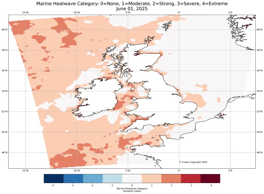
01/06/25: MHW classification from the UK Met Office’s MHW Monitoring Tool.
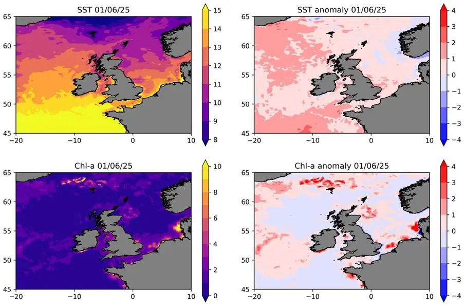
01/06/25: Sea Surface Temperature and respective anomalies (top), chlorophyll-a concentrations and respective anomalies (bottom).
28th May 2025
On Wednesday 28th May, the Sea Surface Temperature (SST) anomalies continued to weaken to <2oC warmer than usual across the entire Northwest European shelf. The majority of UK and Irish waters are now classified as not experiencing a marine heatwave or a category I event. However, offshore waters to the northwest od the UK and Ireland continue to experience a category II marine heatwave along with some small regions along the west UK coast and east and west Irish coast.
The intense phytoplankton blooms that were occurring to the north of the UK have reduced in extent and magnitude with chlorophyll-a concentrations reaching ~6-8mg/m3. The blooms around the southeast and northeast coasts of the UK and in the Irish Sea are still occurring while the blooms in the English Channel appear to be increasing in spatial extent and magnitude with some areas now exceeding 10mg/m3 chlorophyll-a concentrations.
How can marine heatwave affect phytoplankton blooms? Dr Charlotte Williams from the NOC explains:
“Stratification (the vertical layering of seawater of different densities) determines the light and nutrients that are available to phytoplankton. MHWs increase the strength of stratification by increasing the heat input into surface waters, stronger stratification can dampen the upward mixing of nutrient rich deeper water into the well-lit surface waters where phytoplankton reside. MHWs can also impact the temperature that phytoplankton experience in the surface, which can directly affect photosynthesis and metabolic rates. MHWs generally increase Chl a at high latitudes (by increasing the light and/or temperature environment) and decrease Chl a at lower latitudes (by increasing stratification and reducing the upward flux of nutrients).”
She also gives her insights into how the blooms may have been affected during the June 2023 and current 2025 event:
“What we have been seeing around the UK during the current and previous (June 2023) MHW is more intense chlorophyll signals that are outside of the ranges that we would expect based on previous measurements. During the June 2023 MHW, glider measurements in the North Sea showed us that both the surface and subsurface chlorophyll concentrations increased as a result of changing temperature, light and stratification.”
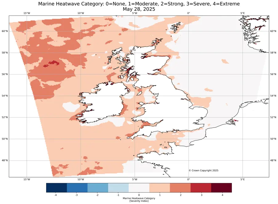
28/05/25: MHW classification from the UK Met Office’s MHW Monitoring Tool.
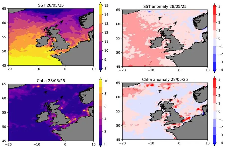
28/05/25: Sea Surface Temperature and respective anomalies (top), chlorophyll-a concentrations and respective anomalies (bottom).
25th May 2025
On Sunday 25th May, the Sea Surface Temperature (SST) anomalies are beginning to weaken across the entire region. To the west of UK and Ireland the anomalies have reduced by >1oC, peaking now at around +2-3oC warmer than usual for this time of year, now classified as a (mostly) category II marine heatwave. Except for coastal waters along the eastern UK coast, the North Sea is no longer experiencing a marine heatwave with SSTs close to average.
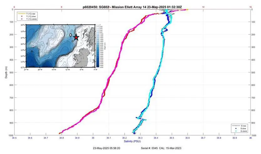
Scientists from Scottish Government’s Marine Directorate are currently collecting data on fish eggs in the area west of Ireland and Scotland on board MRV Scotia. As part of the sampling programme, a Conductivity-Temperature-Depth (CTD) instrument has been used to collect water column profiles of temperature, salinity and other oceanographic parameters in the surface 200 m (see below). Dr Bee Berx provides update on the situation: "Our ship has been well placed to collect CTD profiles in the area of the marine heatwave. Last week, it clearly showed a 3.5-4.5 °C warm layer within 15-20 m depth west of Ireland. Following the intense westerly winds in this area, this layer has now deepened to about 50 m, and the anomaly is closer to ~2-2.5 °C.”
Dr Ségolène Berthou from the Met Office adds: “The westerlies are forecast until the middle of next week and should continue to draw heat out of the ocean into the atmosphere and mix the water column to bring cooler water closer to the surface”.
The phytoplankton blooms in the open ocean off the west coast of Ireland have reduced in strength and extent, with the main area of activity observed to the north of the UK. Widespread blooms continue to develop here with chlorophyll-a concentrations exceeding 10mg/m3. The intense blooms in the southern North Sea and along the southern English coast are still occurring with some growth observed along the eastern UK coast.
What other kinds of impacts could we expect to see? Dr Katie Smith from the Marine Biological Association has shared her insights:
“We don’t know yet what the impacts will be but in recent years when we’ve seen marine heatwaves at this time of year, we’ve seen things like increases in warm water species like bluefin tuna and thresher sharks off the southwest coast of the UK, which has provided a temporary boost to the tourism industry”.
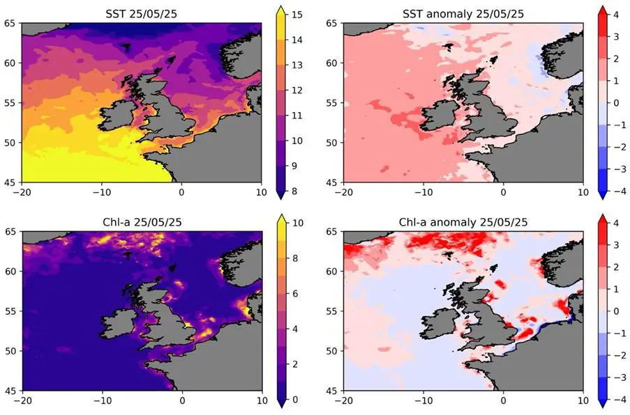
25/05/25: Sea Surface Temperature and respective anomalies (top), chlorophyll-a concentrations and respective anomalies (bottom).
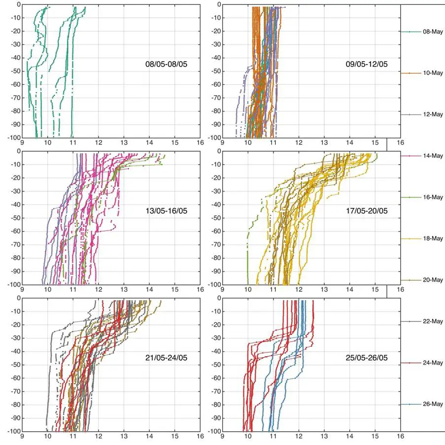
Temperature profiles collected by MRV Scotia between 8 – 26 May 2025 to the west of Ireland and Scotland. The profiles have been zoomed to show only the surface 100 decibars (approx. 100 m). Each panel shows three days’ worth of profiles, and the lines are coloured in two-day sequences. The legend shows the first of the two dates.
21st May 2025
On Wednesday 21st May, the Sea Surface Temperature (SST) anomalies remain high (+3 to 4oC) to the west of Ireland, in the Irish Sea and around the southwest coast of the UK with MHW conditions mostly classified as category II-III. The warming in the North Sea continues to weaken, with the majority of this region no longer experiencing a MHW. Most of the English Channel remains 1-2oC warmer than normal for this time of year, with greater anomalies observed further west.
What is happening beneath the surface? Dr Neil Fraser, a physical oceanographer from the Scottish Association for Marine Science (SAMS) provides some comments on the subsurface data being sampled by an autonomous glider deployed off the west coast of Scotland.
“It looks like the vertical structure is similar to what was seen during the 2023 MHW, with the excess heat really confined to the upper 20-30m, indicating that the extreme values were forced atmospherically. However, the entire water column has been anomalously warm over the past 2-3 years, right down to 1500m (based on our gliders and moorings in the region). That more gradual change in the background state, likely related to changes in ocean circulation, makes these higher frequency atmospheric signals even more impactful.”
Phytoplankton blooms remain in the open ocean of the west coast of Ireland, with some signs of weakening now apparent. In contrast, distinct blooms (>10mg/m3) are intensifying and expanding north of the UK, near the Shetland and Faroe Islands, leading to extensive chlorophyll-a anomalies. The intense blooms in the southern North Sea and along the eastern and southern English coasts are still occurring with minimal changes in spatial extent.
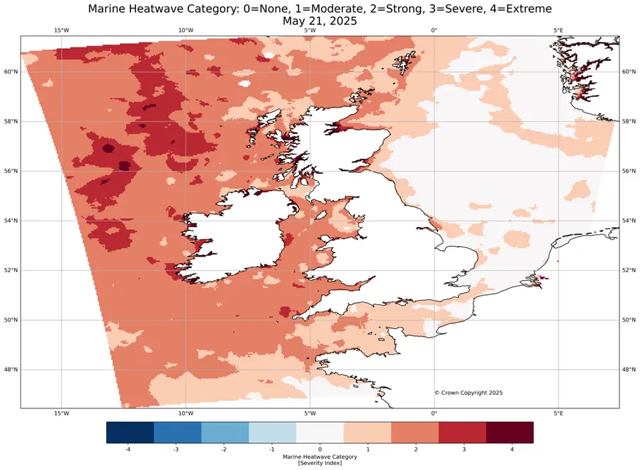
21/05/25: MHW classification from the UK Met Office’s MHW Monitoring Tool.
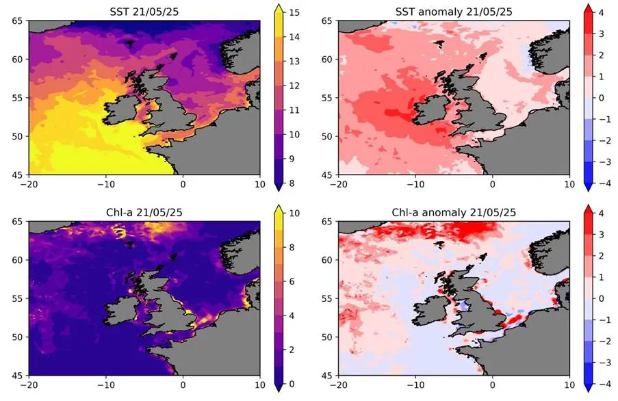
21/05/25: Sea Surface Temperature and respective anomalies (top), chlorophyll-a concentrations and respective anomalies (bottom). NOTE the extended colour bar on the SST anomalies.
Recent (23rd May) temperature and salinity profiles recorded by a glider located west of Scotland, deployed by SAMS.
18th May 2025
On Sunday 18th May, the Sea Surface Temperature (SST) anomalies continued to weaken in the western North Sea & English Channel with these regions now <1oC warmer than usual. However, the SSTs around Ireland have intensified with widespread anomalies of +3oC apparent, reaching almost +4oC off the west Irish coast (note the increased limits of the colour bar below). This region is now experiencing a category II-IV MHW. Waters around the southwest English coast, Scottish & Welsh coasts continue to experience a category II-III event with anomalies of 1-3oC more than normal for this time of year.
The phytoplankton blooms in the open ocean west of Ireland continue to expand and intensify, with widespread positive chlorophyll-a anomalies apparent across the region. Intense blooms in the southern North Sea remain (now peaking at up to 50mg/m3) but their extent appears to be reducing slightly. Weaker blooms are also still apparent in the northern North Sea but the intensity is also weakening here. In contrast the positive chlorophyll-a anomalies (>4mg/m3) are expanding in the Irish Sea and English Channel, with large blooms developing.
What do we know about the impacts on fisheries or harmful algal blooms around the UK? Cefas Scientists Dr Bryony Townhill and Dr Georg Engelhard have given their insights:
“Marine heatwaves are known to cause stress and mortality for marine species, with the impacts of heatwaves on fish, seabirds and marine mammals in the Pacific Ocean some of the most well-known. While the impacts of heatwaves on marine life in the UK are less understood, mass mortalities of whelks were reported following a marine heatwave in 2022, and previous Cefas and NOC research has found links between heatwaves and catches of sole, lobster, seabass and red mullet, suggesting the heatwaves affect the recruitment/breeding of certain species. Marine heatwaves can also lead to harmful algal blooms, which can deplete oxygen levels in the water, with consequences for marine biodiversity, fisheries and human health. As scientists, a key challenge is to understand the extent to which these phenomena are driven primarily by marine heatwaves or other factors, such as pollution or disease. Research is ongoing to find further evidence on the impacts and causes, and we are watching closely with partners, such as the Met Office and NOC, to monitor the impacts of the current UK heatwave on marine life and fisheries.”
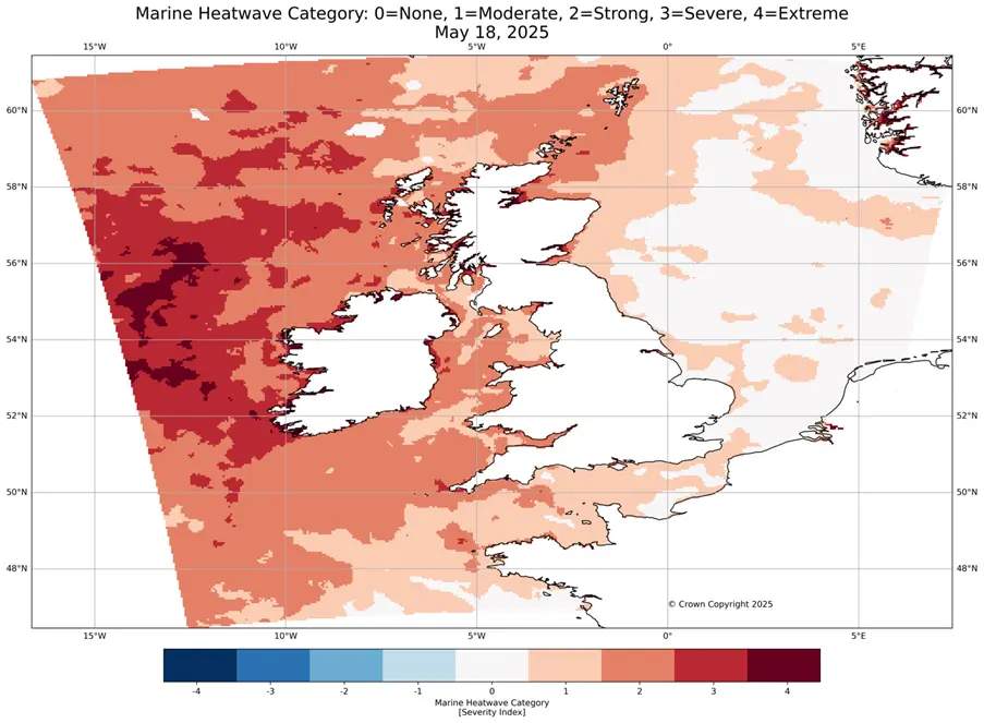
18/05/25: MHW classification from the UK Met Office’s MHW Monitoring Tool.
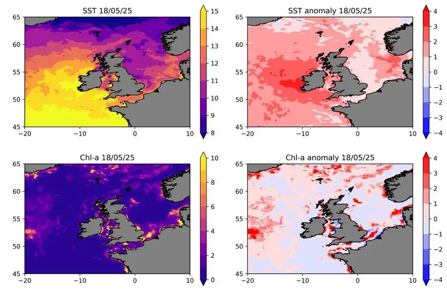
18/05/25: Sea Surface Temperature and respective anomalies (top), chlorophyll-a concentrations and respective anomalies (bottom). NOTE the extended colour bar on the SST anomalies.
14th May 2025
On Wednesday 14th May, Sea Surface Temperatures (SST) remained 1-3oC warmer than usual for this time of year across the entire region. While the majority of the North Sea and English Channel are experiencing a category I MHW, parts of the eastern and southern regions are no longer classified as a MHW, with SSTs around 1oC warmer than usual. The anomalies around the southwest UK coast and much of the Irish coast have intensified to +3oC with these warmer waters also extending further offshore to the west. These regions are undergoing a category II-III MHW. A large portion of Scottish waters are also classified as category II-III with anomalies of 2-3oC expanding northwards.
Intense phytoplankton blooms remain in the southern North Sea and off the coast of East Anglia with chlorophyll-a concentrations of up to 30mg/m3 recorded. While of lower magnitude (8-10 mg/m3), the anomalous blooms around the Shetland Islands and generally north of Scotland are expanding to cover a larger region. Some of the blooms in the open ocean to the southwest of Ireland are also intensifying and expanding. In the Irish Sea and parts of the English Channel, smaller blooms persist with some signs of intensification in the Irish Sea.
An update from Dr Ségolène Berthou from the Met Office on the drivers of this event: “The high-pressure system bringing settled conditions is likely to continue to warm the ocean around the UK and Ireland well into next week. The long-range forecast doesn't indicate any likelihood of weather regimes which could disrupt the MHW until Friday 23rd.”
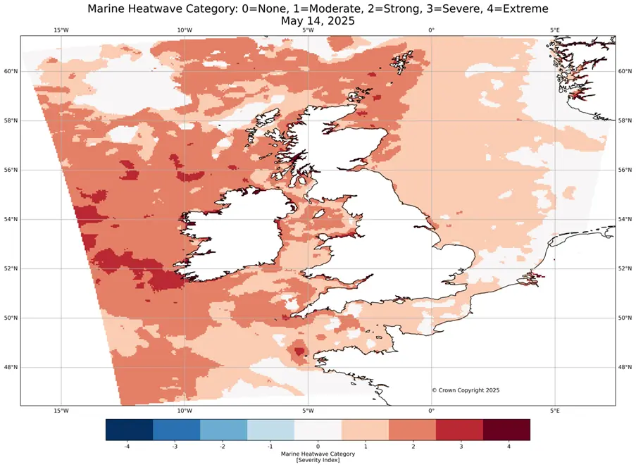
14/05/25: MHW classification from the UK Met Office’s MHW Monitoring Tool.
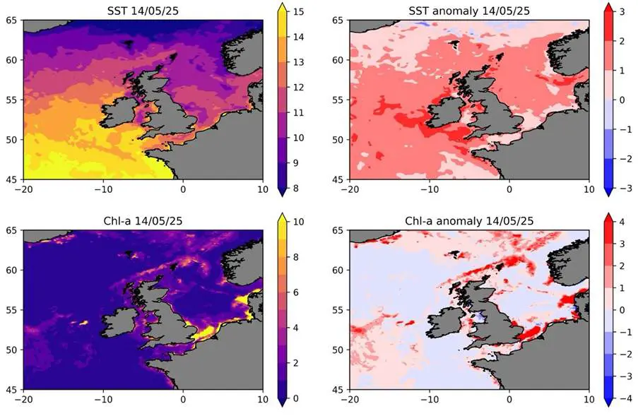
14/05/25: Sea Surface Temperature and respective anomalies (top), chlorophyll-a concentrations and respective anomalies (bottom).
11th May 2025
On Sunday 11th May, Sea Surface Temperatures (SST) remained warmer than usual for this time of year across the entire region. The anomalies in the English Channel and Southern North Sea remained lower than the rest of UK waters (+0-1oC) while the rest of the North Sea has warmed up with widespread anomalies of +1-2oC, and up to +3oC in the eastern North Sea, apparent. The SSTs west of Ireland are also intensifying with the whole region now experiencing +2-3oC anomalies, peaking off the southwest Irish coast. These waters are now classed as experiencing a category II-III MHW. With anticyclonic conditions providing high levels of sunshine and weak winds, these anomalies are anticipated to persist for the rest of the week.
Phytoplankton blooms remain in the open ocean to the southwest of Ireland and in the northern North Sea, off the east coast of Scotland, although their intensity is declining to +2-3mg/m3. However, anomalous blooms are now emerging around the Shetland Islands. Additionally, the chlorophyll-a concentrations in the English Channel and particularly in the Southern North Sea around the East Anglian coast and Thames estuary are intensifying with blooms exceeding 10mg/m3 visible across the entire region. This contrasts with waters off the northeast English coast, which are experiencing weaker phytoplankton blooms than usual for this time of year.
What do we know about the impacts of marine heatwaves on phytoplankton? Dr Elena García-Martín, a plankton ecologist from the NOC, has given some insights:
“There is still a lot of debate on the impact of marine heatwaves on phytoplankton. We don’t know if the increase in temperature has promoted an increase in the phytoplankton blooms and whether it will collapse quickly or persist for a while. The speed of their decline will depend on the environmental conditions over the next few days. The intensity and duration of the bloom are important as they could have consequences on coastal productivity, as well as carbon export to deeper waters.”
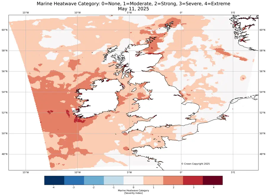
11/05/25: MHW classification from the UK Met Office’s MHW Monitoring Tool.
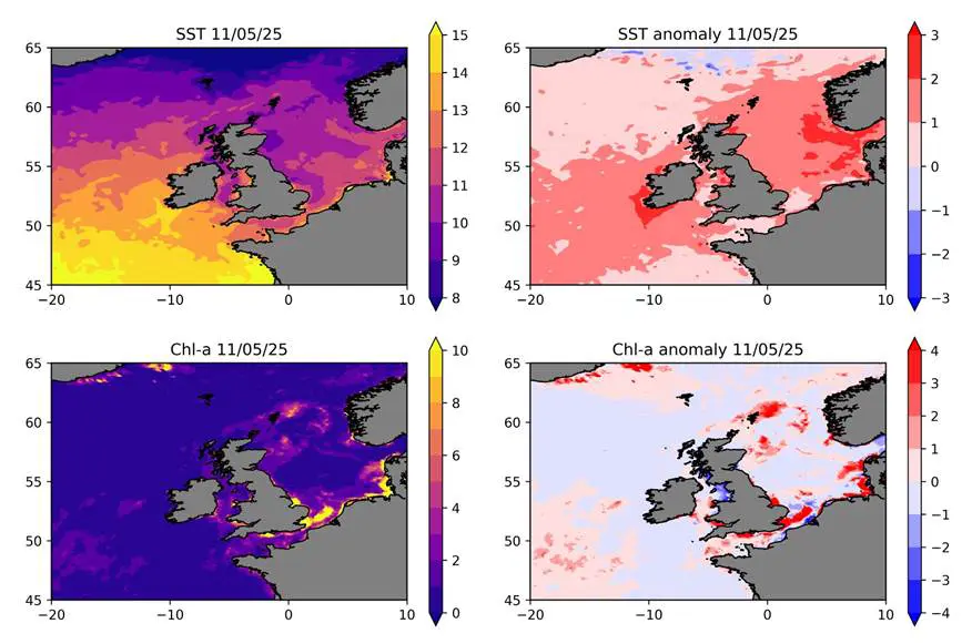
11/05/25: Sea Surface Temperature and respective anomalies (top), chlorophyll-a concentrations and respective anomalies (bottom).
7th May 2025
On Wednesday 7th May, Sea Surface Temperatures (SST) remained 0-1oC warmer than usual for this time of year across the entire region. The southern and central North Sea anomalies continue to decrease slightly with only some areas now classified as a category I MHW. However, the SST anomalies in parts of the northern North Sea, the Irish Sea, the Celtic Sea and the waters to the west of Ireland are intensifying and are now exhibiting anomalies of +2oC. The +3oC anomalies to the southwest of the UK and south of Ireland on 4th May remain visible and appear to be expanding, with +3oC anomalies now also present in the Irish Sea. These regions are all experiencing a category I-III MHW.
But what could be driving the MHW? Dr Ségolène Berthou, a scientist from the Met Office who researches the atmospheric drivers of MHWs, has given insight into what may be driving this current event:
“We've had a long period of "summer-like" weather regimes in March and April – warm, anticyclonic conditions with weak winds. Similar conditions were identified to have led to the June 2023 MHW. At the start of April, tropical air was brought to the UK because of a remote storm over the Atlantic, while an anticyclone centred over Denmark kept low-levels of winds and high levels of sunshine, both contributing to warming SSTs around the UK. Our long-range forecast doesn't show signs of weather regimes which could break this MHW, so it's likely to continue well into next week”. To read more about why spring has been so warm and dry this year, read their recent blog post here.
Phytoplankton blooms continue to develop in the open ocean to the southwest of Ireland and in the northern North Sea, off the east coast of Scotland, with chlorophyll-a anomalies exceeding 4mg/m3. Both regions are currently experiencing anomalous warming of up to 2oC. Blooms of a similar magnitude to that observed on 4th May are still apparent in the western English Channel but continue to subside in strength and coverage off the East Anglian coast and southern North Sea.
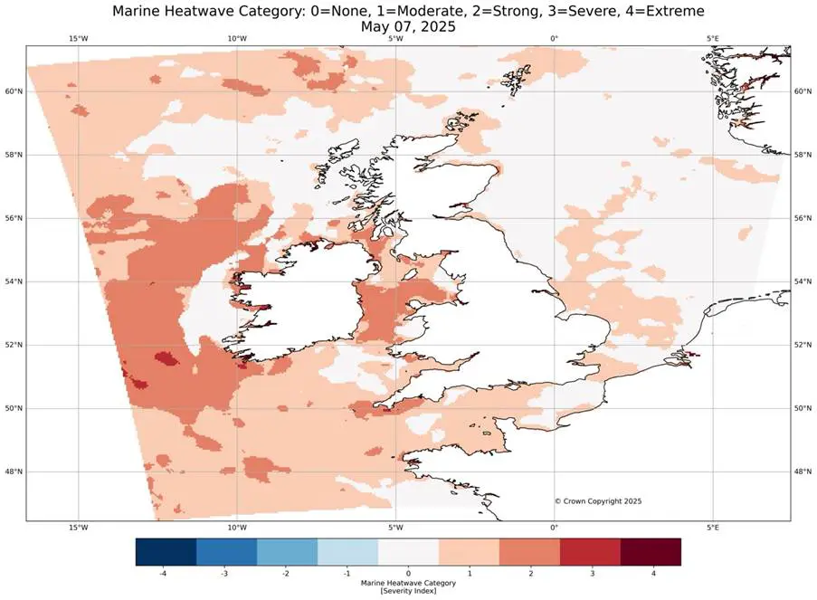
07/05/25: MHW classification from the UK Met Office’s MHW Monitoring Tool.
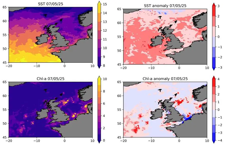
07/05/25: Sea Surface Temperature and respective anomalies (top), chlorophyll-a concentrations and respective anomalies (bottom).
4th May 2025
On Sunday 4th May, Sea Surface Temperatures (SST) remained 0-1oC warmer than usual for this time of year across the entire region, with anomalies of up to +2°c apparent in the central North Sea and off the coast of East Anglia.
To the southwest of the UK and south of Ireland, +3°c anomalies are visible in a few coastal areas while offshore, +2°c anomalies are widespread.
Overall, warm anomalies remain over the entire region, but these have reduced slightly in the southern North Sea since 30th April. Phytoplankton blooms have also subsided in strength and coverage. However, greater than average concentrations (>4mg/m3 ) of chlorophyll-a still exist in the English Channel, Irish Sea and around the East Anglian coast.
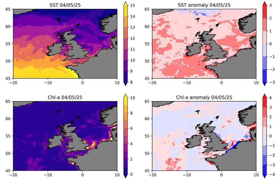
04/05/25: Sea Surface Temperature and respective anomalies (top), chlorophyll-a concentrations and respective anomalies (bottom).
30th April 2025
On Wednesday 30th April, we observed that SSTs were 0-1°c warmer than usual for this time of year across the entire UK region, with anomalies of up to +3°c apparent in the southern North Sea and off some of the UK’s southwest coast.
While most of the North Sea shows minimal chlorophyll-a anomalies, phytoplankton blooms are visible, and larger than usual (>4mg/m3), off the east coast of Scotland and the Shetland Islands and around East Anglia. Anomalously large blooms are also apparent in much of the English Channel and in the Irish Sea.
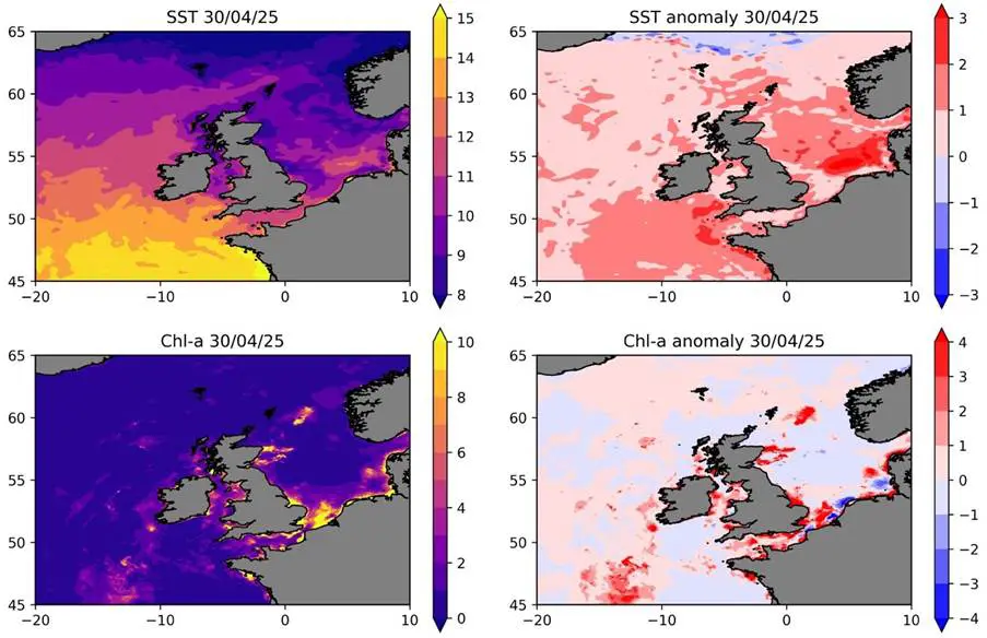
30/04/25: Sea Surface Temperature and respective anomalies (top), chlorophyll-a concentrations and respective anomalies (bottom).
Stay tuned for the next update.
View the data
Download near-real-time satellite remote sensing data at the following links:
Be part of the community helping our ocean thrive.
What Do We Know About Marine Heatwaves Around the UK?
A recent study led by NOC revealed where marine heatwave events are most likely to occur in UK waters, for the first time. The study, led by NOC’s Dr Zoe Jacobs and published in Frontiers in Marine Science, shows there are regional marine heatwave hotspots in the Southern North Sea and English Channel. Events here are weaker than in other areas around the UK, but last longer.

Related Resources
Learn more about marine heatwaves and NOC's research aimed at learning more about their behaviour below. This includes educational pages and latest news.


