Human impact on the deep ocean is rapidly increasing, with largely unknown consequences. Effective management and conservation, based on an ecosystem approach, is hampered by our poor understanding of the deep-sea environment.
Measuring biodiversity, the main indicator of ecosystem status and functioning, is a major challenge in deep water: traditional sampling schemes are expensive and time-consuming, and their limited coverage makes it difficult to relate the results to regional patterns. Complex deep-sea environments are especially problematic. Ecosystem hotspots such as canyons or coral reefs contain true 3D morphology that cannot be surveyed with conventional techniques. CODEMAP will quantify habitat heterogeneity in complex deep-sea terrains, and will evaluate its potential as a proxy for benthic biodiversity at a variety of scales. Habitat heterogeneity has been suggested as a major driver for deep-sea biodiversity, but is rarely quantified in a spatial context in the marine realm.
To achieve its goal, CODEMAP will combine the fields of marine geology, ecology, remote sensing and underwater vehicle technology to establish an integrated, statistically robust and fully 3D methodology to map complex deep-sea habitats. Statistical techniques will be developed to extrapolate quantitative habitat information from fine scale surveys to broad scale maps. The optimal parameters to measure habitat heterogeneity will be defined, and their potential as biodiversity indicators tested through correlation with traditional approaches. The project focuses on submarine canyons, but the techniques will also be transferred to other environments. CODEMAP is expected to have a strong impact on the fundamental understanding of the deep sea and on ecosystem-based deep-sea management.
PI: Dr Veerle Huvenne
Email: vaih at noc.ac.uk
European Union
The aim of CODEMAP was to develop an integrated, robust and fully three-dimensional methodology to map complex deep-sea habitats, to quantify their heterogeneity and to test if heterogeneity measures derived at different scales reflect epibenthic megafauna biodiversity.
CODEMAP focused at first on submarine canyons, but the techniques would be transferable to other deep-sea environments, for example, cold-water coral reefs or mid-ocean ridges.
We started from existing datasets collected during the HERMES and HERMIONE projects, or under the NERC OCEANS2025 and MAREMAP programmes, but new data will be collected during two further expeditions:
- JC060 (May/June 2011) on board the RRS James Cook. This cruise will be used to develop specific techniques while carrying out habitat mapping for the assessment of trawling impacts and conservation results.
- A second cruise, now scheduled for summer 2015, returning to Whittard Canyon (Celtic margin) to ground-truth the classifications developed in CodeMAP, to monitor potential changes, and to further test sideways mapping techniques.
Research
Top-down analysis
Robust mapping of habitats and marine landscapes on the regional to medium scale
Work package WP1 involves:
- Development of objective classification methods for deep marine landscapes
- Evaluation of different automated image segmentation techniques for (AUV/ROV-based) multibeam and sidescan sonar data
- Performance assessment through replicate surveys
- Development of a confidence assessment methodology
Results:
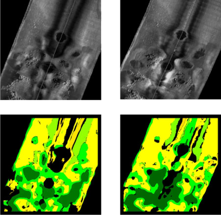
- Objective automated classification technique for marine landscape mapping in complex deep-sea environment, including confidence assessment
- published in Marine Geology (Ismail et al., 2015)
- Application for mega-MPA characterisation published in Nature Scientific Reports (Hogg et al., 2016)
- Summarised in handy CODEMAP 2-page factsheet
- New toolbox for the ArcGIS 10.x software to support automated image segmentation. Also summarised in the CODEMAP 2-page factsheet
Quantification of habitat heterogeneity
Evaluation of its potential as a proxy for biodiversity
Work package WP2 quantifies habitat heterogeneity:
- Adapting terrestrial landscape ecology metrics based on categorical maps
- Using geostatistical descriptions based on spatially continuous variables
- Combining both techniques through the use of fuzzy classification schemes
- Testing the correlation of these parameters with traditional biodiversity indices.
Results:
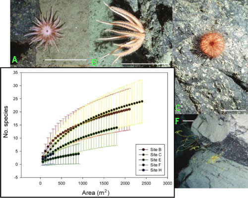
- Using landscape ecology indices to improve predictions on megafauna distribution and diversity
- Published in MEPS (Robert et al., 2014).
- Summarised in a handy CODEMAP factsheet
Bottom-up analysis
Finding quantitative relationships that can bring infomation from a more detailed to a broader scale
Work package WP3 aims:
- Extrapolating the maximum amount of quantitative information from the highest-resolution data (which have limited coverage) to the extensive surface area covered by the lower resolution data
- Based on nested optical/acoustic surveys with medium-scale sidescan sonar data as stepping-stone
- An evaluation of fractal theory and novel kriging algorithms.
Results:
- Predicting diversity distributions in Whittard Canyon (Robert et al., 2015 in Marine Ecology)
- Combining model outputs using ensemble techniques to create more robust predictions (Robert et al., 2016 in Deep-Sea Research)
Mapping and visualisation
Work package WP4 includes:
- Mapping of deep-sea cliffs and overhangs using underwater vehicles (AUV/ROV) in ‘sideways’ or ‘front-looking’ mode
- Visualisation through point-cloud models and voxel-based TINs (Triangulated Irregular Networks)
- Derivation of 3D habitat heterogeneity measures.
Results:
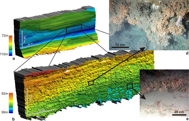
- Spectacular results of our initial tests of the ‘front-looking’ ROV-based mapping (Huvenne et al., 2011 in PLOS ONE)
- Application of this mapping technique to image a submarine landslide headwall scarp (Huvenne et al., 2016)
- Summary of the approaches developed in CODEMAP in a handy 2-page factsheet

Veerle Huvenne
- Marine geoscientist specialised in habitat mapping
- As CODEMAP project leader, Veerle coordinates the project
- Veerle will also coordinate work packages WP1 and WP3

Daniel Jones
- Benthic biologist, specialised in benthic ecology; Dan is leader of the SERPENT project
- Within CODEMAP, Dan coordinates work package WP2, comparing the new methods with traditional biodiversity measures

Tim Le Bas
- Marine geologist and geophysicist, specialised in acoustic seabed mapping
- Tim will develop the methodology for AUV backscatter and sidescan sonar processing
- In addition, Tim keeps an eye on the data management and GIS of the project

Steve McPhail
- Underwater systems engineer, head of Autosub6000 team
- Steve is responsible for the further development of the Autosub6000 AUV (work package WP4), to allow the sideways mapping and to provide high-resolution optical datasets

Katleen Robert
- Katleen is a benthic biologist who moved over from Canada to write her PhD here at NOC; she has plenty of experience in habitat mapping
- In her PhD, she focused on predictive habitat mapping in submarine canyons – she analysed imagery transects to map megabenthic invertebrate distributions and determined which environmental factors, mostly derived from acoustic survey techniques, are most useful in explaining the spatial structure observed
- Katleen has now taken up a position as post-doctoral researcher within CODEMAP, applying her skills to the problem of habitat mapping in 3 dimensions (WP4)

Khaira Ismail
- Marine geologist, and the second PhD student in our team; Khaira’s PhD work focuses on examining habitat heterogeneity as proxy for biodiversity in deep-sea complex environments
- Within CODEMAP, she develops top down techniques for objective deepsea marine landscape mapping, derivation of habitat heterogeneity indices and quantification of fuzzy boundaries

Claudio Lo Iacono (associate team member)
- Claudio came to the National Oceanography Centre, Southampton as a Marie-Curie Postdoctoral Research Fellow, and was previously based at the CSIC in Barcelona. He now has a permanent position at NOC as Principal Scientist.
- He has a vast range of experience in acoustic seafloor characterization, quantitative backscatter analysis and image segmentation for integrated seafloor classifications – his expertise strengthens our team.

Veit Hühnerbach (previous member)
- Marine geologist with more than 20 years experience in acoustic seabed mapping and classification
- Veit supported CODEMAP in its first 2.5 years as web manager and research scientist
- He has now left the team for pastures new
Second CODEMAP Cruise: JC125

On 9 August 2015, the CODEMAP team, together with a group of 30 scientists and engineers, will finally set sail from Southampton for their long-awaited expedition back to Whittard Canyon!
The aims of the cruise are:
- To carry out further habitat mapping at different resolutions in Whittard Canyon, to increase our understanding of the system and to test and improve the predictive habitat models built within CODEMAP using the 2009 data
- To test and apply further sideways multibeam mapping, in order to develop a true 3D habitat model of the canyon
- To revisit key habitats in the canyon in order to establish potential changes over the last 6 years
- To measure the water column structure in the Eastern Branch of Whittard Canyon, to allow the inclusion of oceanographic parameters in the predictive habitat models.
More information about the cruise, the team, and what we'll discover can be found on the cruise website!
First CODEMAP Cruise: JC060
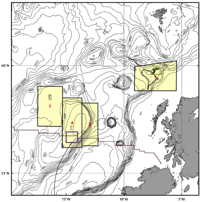
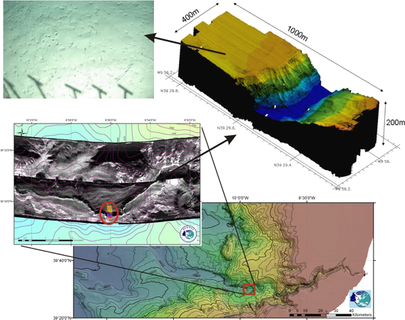
On 9 May 2011, the RRS James Cook sets sail from Glasgow for a 34-day expedition to the Rockall Trough, Rockall Bank and Hatton Basin. The aim of the cruise is to carry out habitat mapping, in order to investigate:
- The different benthic biotopes that occur in those study areas, including their physical environment and faunal communities
- Human impacts on those habitats, especially from deep-sea trawling activities
- The effect of conservation measures.
We visit four study areas, each with its own story (see map):
- The Darwin cold-water coral mounds
- The steep flanks of Rockall Bank with their potential ‘hanging gardens’
- Enigmatic polygonal faults in Hatton Basin
- Upper Rockall Bank, where areas of intense trawling and seabed protection occur right beside each other.
Catch the Next Wave
Our fantastic results from the CODEMAP2015 expedition formed the core of an invited contribution to the Catch the Next Wave conference at the Royal Institution in London on 14 March 2016. Veerle was presenting how we used a fleet of marine robots to map Whittard Canyon in all its facets.
RRS Discovery in London
To celebrate 50 years of the Natural Environment Reserach Council, our newest vessel, RRS Discovery, was moored in London between 7 and 12 October 2015. Our CODEMAP work and results formed one of the main displays of the event, presented in and around the ROV Isis and AUV Autosub, just as we collected the actual data less than a month before.
CODEMAP2015
On 9 August 2015 it finally happened: the looooooong awaited second CODEMAP cruise! A team of 28 scientists and technicians joined the RRS James Cook in Southampton, and sailed for 5 weeks to the Whittard Canyon and Haig Fras MCZ site. You can follow their adventures on our cruise blog.
Dr Khaira Ismail!
On 29 June 2015 was a very special day for Khaira: her PhD viva! She defended well, and can now be called Dr Ismail! Khaira is moving back to her native Malaysia to take up a position as university lecturer. We are sad to see her go, but wish her all the best in the future. We'll stay in touch!
ERC 5000th Grantee Event
 The ERC has recently celebrated its 5000th grantee with an event at the Bibliotheque Solvay in Brussels. As part of the evening, several grantees presented their projects to show the wide range of research supported by the ERC. Veerle went to present CODEMAP, and to launch our upcoming CODEMAP2015 expedition! A summary of the presentation was also published as an ERC article.
Geohab2015
Our annual presence at Geohab was a bit reduced this year, as most team members were either at sea or frantically writing up their PhD... Still, Tim and new PhD student Lissette Victorero joined the community of habitat mappers in Salvador, Brazil, and showed our latest discoveries in terms of automated seabed segmentation software and seamount mapping.
New software for Object Based Image Analysis
Over the last months, Tim Le Bas has developed a new toolbox for the popular GIS softward ArcGIS, to allow Object Based Image Analysis and segmentation.
Habitat mapping of nodule fields
Joining the RRS James Cook in the Clarion-Clipperton Zone (Pacific), Katleen and Veerle will apply CODEMAP habitat mapping techniques to a new environment: deep-sea polymetallic nodule fields. Expedition JC120 is organised within the framework of the EU project MIDAS, and aims to contribute to the assessment of environmental impacts from the extraction of mineral and energy resources from the deep sea.
Hotspots
Katleen's second paper from her PhD has just appeared in Marine Ecology: "Finding the hotspots within a biodiversity hotspot: fine-scale biological predictions within a submarine canyon using high-resolution acoustic mapping techniques"
Mapping marine landscapes in the deep sea
Khaira's first paper from her PhD, presenting the robust, objective and automated classification technique she has been developing for submarine canyons, has just been published in Marine Geology. The associated press release immediately attracted the attention from BBC Radio Solent, and Veerle dropped in on their evening drive-time to tell the audience more about it.
Dr Katleen Robert!
On 8 October 2014, Katleen Robert successfully defended her PhD thesis! Congratulations Dr. Robert! The whole team is very proud!
And what is more: from January onwards, Katleen will continue her work within the team, as she successfully applied for the CODEMAP post-doc position. We are looking forward to continue working with you, Katleen!
Submarine Canyons take centre stage
Two years after the first edtition, the 2nd International Symposium on Submarine Canyons in Edinburgh, aka INCISE2014, was a resounding success! With submarine canyons being the main study environment for CODEMAP, it wasn't surprising the team gave a strong performance! Check out presentations by Khaira, Katleen and Claudio.
Nature paper!
Exciting moment: Veerle's first contribution to the famous journal Nature! As ERC Grantee, she contributed to an article about Early Career Funding. Not exactly the typical Nature paper that gains masses of citations, but still a nice event
CUMECS-2
Following the very successful CUMECS expedition in 2012, the team has once again gathered on board an Italian research vessel (RV OGS Explora) to continue the mapping work of the enigmatic Malta Escarpment. This time we're aiming for the deeper parts, attempting to characterise as many canyons as possible. Follow us on http://cumecs2.blogspot.co.uk/p/home_3.html
SORBEH! (aka 'Slope collapses On Rockall Bank and Escarpment Habitats')
CODEMAP have teamed up with our colleagues from the University College Dublin for an additional cruise, looking at a new type of near-vertical deep-sea habitat: submarine landslide escarpments! Follow their activities on the blog of the Celtic Explorer: scientistsatsea.blogspot.co.uk
Garbage in our oceans
Data collected during the first CODEMAP cruise (JC060) contributed to an important assessment on the amount of human litter in our European Seas. The situation is rather shocking: litter can be found in every single part of our oceans! Veerle spoke on the BBC Radio 4 show 'Costing the Earth' about what we found...
Strong CODEMAP presence at GeoHAB
In good annual tradition, the CODEMAP team made a real splash at the annual GeoHAB conference, this year in Lorne, Australia. There were talks by Tim, Katleen, Claudio, Khaira and Veerle, and we successfully secured the honour to host GeoHAB in the UK in 2016!
Megafauna distributions from Rockall Bank
Katleen's first paper from her PhD discusses the megafaunal distribution and diversity in the heterogeneous landscape of Rockall Bank. It is based on the data we gathered during the first CODEMAP expedtion, JC060, and is published in Marine Ecology Progress Series.
Submarine Canyons special issue
Submarine Canyons are a hot topic! Together with Dr. Jaime Davies, Veerle is leading the INCISE network (International Network for submarine Canyon Investigation and Scientific Exchange). As a result of the first meeting in 2012, a new special issue on Submarine Canyons has just come out with Deep-Sea Research II. Check out Claudio's and Veerle's papers in it!
ERC coral connections
The CODEMAP project is funded by the ERC (European Research Council), which provides a fantastic support to create top-level science. Imagine what happens when 2 ERC grantees join forces?! This is exactly what will happen on expedition JC094! Follow the blog for more information!
Goodbye Veit...
After more than 15 years at the National Oceanography Centre in Southampton, our team member Veit Hühnerbach is going back to his native Germany. We wish him all the best in his new position at Geomar, and will miss him here in CODEMAP!
Mid-way!!!
Can you believe it? The CODEMAP project is already mid-way! Looking back over the past two-and-a-half years, we have done a lot of work, and the first results are coming out. Soon there will be more!
European Marine Biology Symposium
Katleen went to represent CODEMAP at the European Marine Biology Symposium in Galway! She presented her recent work on the Whittard Canyon, and took part in the habitat mapping workshop.
Almost May... it is time for GEOHAB again
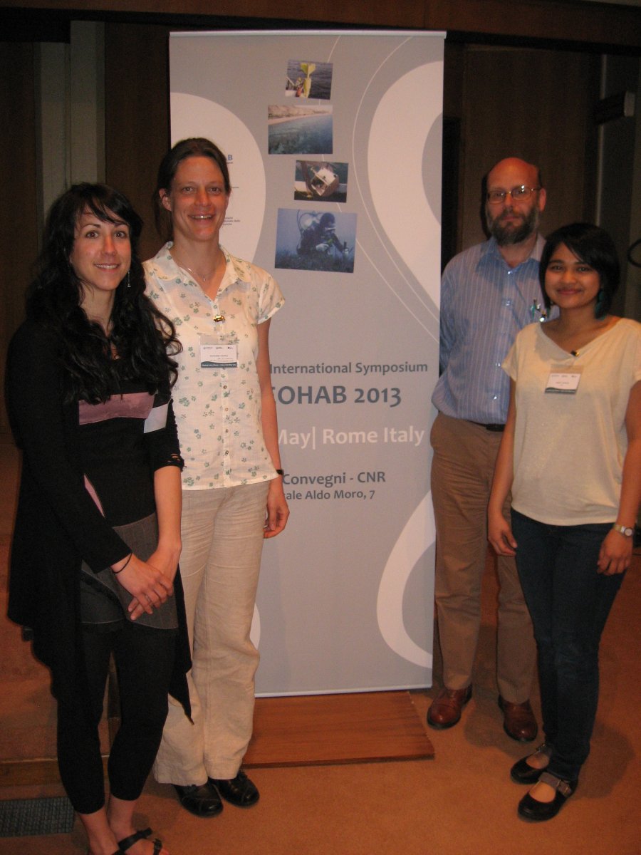
This year, most of us will be heading to the ancient city of Rome for the 2013 Meeting. Tim, Katleen, Khaira, Veerle and Claudio will use this specialist meeting to present and discuss the latest habitat mapping results. (Apr 2013)
CODEMAP in the news again!
Veerle has been interviewed by the German initiative to promote excellent female researchers – AcademiaNet. (Apr 2013)
EGU Conference in Vienna (more than just drinking coffee)
This year's EGU-Conference in Vienna, Austria, has been very busy. Veerle co-chaired a session on Submarine Canyons where Claudio presented some of his work. While they were on the continent, they launched INCISE, the 'International Network for submarine Canyon Investigation and Scientific Exchange'. (Apr 2013)
Katleen is going down under
Katleen is on her way to the 13th International Deep-Sea Biology Symposium in Wellington, New Zealand. She will talk about landscape ecology under water, as part of her PhD work. (Dec 2012)
Veerle's second home – the RRS James Cook
Hands-on science in the Southern Oceans is the bait to get Veerle out to sea again. This time it is the JC80 expedition to the hydrothermal vent sites of the East Scotia Ridge. Veerle will be testing the new high-resolution multibeam system on the re-built ROV ISIS. (Dec 2012)
Part of a huge success story!
With the very successful EU-funded Hermione Project coming to an end in September 2012, Veerle, Katleen and Khaira go to its final meeting in Faro, Portugal to present the first results of CODEMAP.
... and now on to rainy Brittany
Once off the ship with a spectacular dataset, Veerle, Claudio and Khaira go straight to Brest, France, for the First International Symposium on Submarine Canyons. This initiative brings together scientists from different background working on this interdisciplinary topic.
Mapping Canyons in the sunny Med...
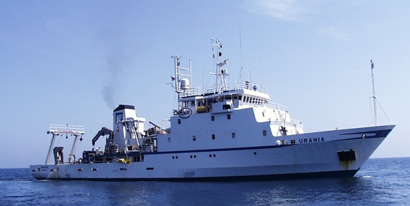
Tim, Veerle, Khaira and Claudio join a Eurofleets funded expedition onboard the R/V URANIA. The submarine canyons are the prime target deep-sea environment of CODEMAP, and the participation in the CUMECS cruise provides the team with a new dataset on which it can test the latest habitat mapping methodologies. There is a cruise blog and even a YouTube video. (Jun 2012)
CODEMAP advises the Changing Oceans Team at sea during JC73...
Veerle provides the Bio-team with the important spatial context on the effect in which ocean acidification happens... and, in return, gets an ultra- high-resolution dataset from the ROV. Read all about this trip on the blog. (May 2012)
Off to Orcas Island!
A year after CODEMAP started, three of our team will be off to the 2012 Geohab Meeting held on the largest of the San Juan Islands, between Washington State, USA, and Vancouver Island, Canada. Tim, Katleen and Khaira will all give presentations. Katleen and Khaira received special student travel grants for their partcipations – Big Thanks to Geohab!!! (Apr 2012)
Welcome to Claudia Lo Iacono
Claudio, a Marie-Curie Postdoc fellow, joined us from CSIC in Barcelona for the coming two years. Welcome!
Corals are one of our topics
It is time for the Cold-water Coral Symposium in Amsterdam. Veerle will present the first results of last year's JC60 expedition – the state of the Darwin Mounds after eight years of protection! (Mar 2012)
Early Career Researcher Award!
For all her amazing work, Veerle received the Early Career Researcher Award (with a travel grant to a conference).
How to put a picture on the wall – underwater
Veerle just published our first scientific paper on how to map coral communities on a vertical wall of a submarine canyon. And, of course, it is also in the NOC Newsletter! (Dec 2011)
Off to a flying start – our first CODEMAP cruise!
Almost all of us will be away for the coming 5 weeks because we're going to sea. And we are taking a lot of kit with us on the RRS James Cook! There is the AUV, HyBIS, coring gear and a rental ROV to keep us busy (and entertained). Check the expedition website. (May 2011)
How it all started
Veerle receives the ERC starting grant! Read it in the news. (Oct 2010)
Publications
Links to the main outputs from our work
Video materials
CODEMAP has its own video library on the NOC News YouTube channel! With short documentaries, stunning clips of marine life, and demonstration videos of the new techniques in 3D mapping of submarine canyons.
Protocol Documents
Handy summaries of the main techniques and methods developed during the CODEMAP project, with reference to relevant literature and full description:
- Objective mapping of complex marine landscapes
- RSOBIA: a new OBIA toolbox and toolbar for ArcGIS
- Mapping vertical and overhanging terrain in the deep sea
- Using landscape indices to explain biological patterns
Papers
Fernandez-Arcaya, U. et al. (2017) Ecological role of submarine canyons and need for canyon conservation: a review. Frontiers in Marine Science.
De Clippele, L.H. et al. (2016) Using novel acoustic and visual mapping tools to predict the small-scale spatial distribution of live biogenic reef framework in cold-water coral habitats. Coral Reefs
Micallef, A. et al. (2016) Outer shelf geomorphology along a carbonate escarpment: the eastern Malta Plateau, Mediterranean Sea. Continental Shelf Research
Hogg, O.T. et al. (2016) Landscape mapping at sub-Antarctic South Georgia provides a protocol for underpinning large-scale marine protected areas. Scientific Reports
Morris, K.J. et al., 2016. Landscape-scale spatial heterogeneity in phytodetrital cover and megafauna biomass in the abyss links to modest topographic variation. Scientific Reports.
Amaro, T. et al., 2016. The Whittard Canyon - a case study of submarine canyon processes. Progress in Oceanography.
Huvenne, V.A.I. et al., 2016. Effectiveness of a deep-sea cold-water coral Marine Protected Area, following eight years of fisheries closure. Biological Conservation
Robert, K. et al., 2016. Improving predictive mapping of deep-water habitats: considering multiple model outputs and ensemble techniques. Deep-Sea Research
Huvenne, V.A.I., Wynn, R.B. & Gales, J.A., 2016. RRS James Cook cruise 124-125-126, Report: CODEMAP2015, habitat mapping and ROV vibrocorer trials around Whittard Canyonn and Haig Fras.
Victorero, L. et al., 2015. Reconstruction of the formation history of the Darwin Mounds, N Rockall Trough: how the dynamics of a sandy contourite affected cold-water coral growth. Marine Geology
Huvenne, V.A.I. et al., 2016. Novel method to map the morphology of submarine landslide headwall scarps using Remotely Operated Vehicles. In: Lamarche, G. et al., Submarine mass movements and their consequences, 7th International Symposium. Advances in Natural and Technological Hazards Research, 41, Springer,
Angeletti, L. et al., 2015. First report of live deep-water cnidarian assemblages from the Malta Escarpment. Italian Journal of Zoology.
Ismail, K. et al., 2015. Objective automated classification technique for marine landscape mapping in submarine canyons. Marine Geology.
Morris, K. et al., 2014. A new method for ecological surveying of the abyss using autonomous underwater vehicle photography. Limnology and Oceanography.
Robert, K. et al., 2015, online. Finding the hotspots within a biodiversity hotspot: fine-scale biological predictions within a submarine canyon using high-resolution acoustic mapping techniques. Marine Ecology
Micallef, A., et al., 2014. The Malta-Sicily Escarpment:mass movement dynamics in a sediment-undersupplied margin. Submarine mass movements and their consequences.
Wynn, R., Huvenne V.A.I., et al., 2014. Autonomous Underwater Vehicles (AUVs): their past, present and future contributions to the advancement of marine geoscience. Marine Geology
Pham, C.K. et al., 2014. Marine litter distribution and abundance in European Seas, from the shelf to deep basins. PLoS One
Weaver, P. & Huvenne, V. 2013. Seabed mapping and its contribution to the goal of sustainable management in the ocean. Progress in Marine Conservation in Europe, Proceedings of the Symposium.
Robert K. et al., 2014. Megafaunal distribution and biodiversity in a heterogeneous landscape: the iceberg scoured Rockall Bank, NE Atlantic. MEPS.
Huvenne, V.A.I. & Davies, J., 2014. Towards a new and integrated approach to submarine canyon research. DSRII.
Huvenne, V.A.I. et al., 2011. A picture on the wall: innovative mapping reveals cold-water coral refuge in submarine canyon. PLoSOne.
Abstracts
6th International Symposium on Deep-Sea Corals, Boston, US
Victorero, L. et al., 2016. Reconstruction of the formation history of the Darwin Mounds, N Rockall Trough: how the dynamics of a sandy contourite affected cold-water corals
Huvenne, V.A.I. et al., 2016. Effectiveness of the Darwin Mounds Marine Protected Area, following eight years of fisheries closure
Lo Iacono, C. et al., 2016. Living reefs and CWC mounds in the Alboran Sea (Western Mediterranean). Holocene evolution and present-day conditions.
Robert, K., et al., 2016. Hanging gardens : vertical walls from images to fine-scale 3D reconstructions.
Huvenne, V.A.I. et al., 2016. From pixel to polyp: using novel robotic technology to achieve an integrated multiresolution 3D characterisation of cold-water coral habitats in submarine canyons.
INCISE2016, Victoria, British Columbia, Canada
Eggett, A. et al., 2016. Collecting evidence to inform management discussions within deep-sea canyon environments.
Robert, K. et al., 2016. Whittard Canyon’s eastern branch : zooming in from tidal models to fine-scale photogrammetry.
Amaro, T. et al., 2016. The Whittard Canyon – a case study of submarine canyon processes.
Huvenne, V.A.I., 2016. Obtaining an integrated, multiresolution picture of a single submarine canyon system.
Kershaw, C. et al., 2016. Origin, transport and burial of organic matter in the Whittard Canyon, North East Atlantic.
Gales, J. et al., 2016. Active processes influencing the morphology of submarine gullies – new insights from marine robotics.
Carter, G. et al., 2016. Geomechanical properties of submarine bedrock cliffs : controls on rock slope failures within the Whittard Canyon, Celtic Margin.
Lo Iacono, C. et al., 2016. Upslope vs. Downslope asymmetric bedforms at the head of a submarine canyon.
GeoHAB2016, Winchester, UK
Victorero, L. et al., 2016. The role of food input in shaping biodiversity patterns in benthic seamount habitats across the Equatorial Atlantic.
Simon-Lledo, E. et al., 2016. Megafauna distribution patterns along different geomorphological units in the APEI-4 of the Clarion Clipperton Fracture Zone.
Robert, K. et al., 2016. Hanging gardens : vertical walls from images to fine-scale 3D reconstructions.
De Clippele, LH. et al., 2016. Using novel mapping tools to predict the small scale spatial distribtution of cold-water coral in the Mingulay Reef Complex.
Huvenne, V.A.I. et al., 2016. Mapping a submarine canyon in all its facets.
Hogg et al., 2016. Landscape mapping at sub-Antarctic South Georgia provides a protocol for underpinning large-scale marine protected areas.
GeoHAB2015, Salvador, Brazil
Le Bas, T. et al., 2015. A new Object Based Image Analysis toolbar for ArcGIS 10.x designed for combined multibeam bathymetry and backscatter interpretation, p70.
Roche, M., Le Bas, T., et al., 2015. Backscatter patch test - inter-comparison of systems using shared reference areas for testing, calibration and quality assessment, p35.
Victorero, L. et al., 2015. Spatial patterns of biodiversity on Carter Seamount, Eastern Equatorial Atlantic; scales and drivers, p48.
EGU 2015, Vienna, Austria
Le Bas, T. et al., 2015. Mimicking human expert interpretation of remotely sensed raster imagery by using a novel segmentation analysis within ArcGIS, p6351.
INCISE2014: 2nd International Symposium on Submarine Canyons, Edinburgh, Scotland
Ismail, K. & Huvenne, V.A.I., 2014. Object-based image analysis of sidescan sonar data for mapping sedimentological patterns in submarine canyons, p24.
Robert, K. et al., 2014. Locating hotspots: multi-scale analysis of biodiversity within a submarine canyon, p25
Lo Iacono, C. et al., 2014. Was the 1531 Lisbon tsunami generated by a landslide along the Cascais Canyon? Preliminary results, p45.
2nd Deep-Water Circulation Congress: "The Contourite Logbook", Gent, Belgium
Huvenne, V.A.I., et al., 2014. The Darwin Mounds, N Rockall Trough: how the dynamics of a sandy contourite influenced cold-water coral growth, p 51-52.
Lo Iacono, C. et al., 2014. Morphology and shallow stratigraphy of the West Melilla and Cabliers CWC Mounds (Alboran Sea): preliminary insights from the GATEWAYS MD194 cruise, p115-116.
World Conference on Marine Biodiversity 2014, Qingdao, China
Robert, K., et al., 2014. Locating hotspots: multi-scale analysis of biodiversity within a submarine canyon, p103.
GeoHAB 2014, Lorne, Australia
Huvenne, V.A.I. et al., 2014. GLCM or OBIA? Combining the best of both methods to map cold-water coral stands in the Rockall area (NE Atlantic), p45.
Ismail, K. et al., 2014. Automated classification and OBIA of sidescan sonar imagery and multibeam bathymetry to map submarine canyons, p47.
Le Bas, T.P. et al., 2014. The automation of multibeam processing and interpretation for habitat mapping, p58.
Robert, K. et al., 2014. Finding the hot-spots within a biodiversity hotspot: fine-scale biological predictions within a submarine canyon, p87.
Robert, K. et al., 2014. Multiscale analysis of information content: how much information is lost and which scale should be used?, p88.
Lo Iacono, C., Robert, K. et al., 2014. Predictive ensemble maps for cold-water coral distributions in the Cap de Creus Canyon (NW Mediterranean). Advantages and limitations, p61.
Ocean Sciences Meeting, Honolulu 2014
Huvenne, V.A.I. et al., 2014. Habitat heterogeneity and biodiversity in Whittard Canyon, Celtic Margin, NE Atlantic.
Lo Iacono, C. et al., 2014. Submarine Canyons of North-Western Sicily (Southern Mediterranean Sea): morphologies, sedimentary processes and evolution on a tectonically active margin.
European Marine Biology Symposium, Galway 2013
Robert, K., et al., 2013. The importance of vertical structures for biodiversity in submarine canyons - pg73
GeoHab 2013
Huvenne, V.A.I., et al., 2013. Monitoring of deep-water conservation areas through AUV sidescan sonar mapping: checking the status of the Darwin cold-water coral mounds after 8 years of protection.
Ismail, K., et al., 2013. Multiscale analysis of abiotic parameters for automated deep sea habitat mapping.
Le Bas, T.P., et al., 2013. Ultra-high resolution acoustic survey in turbid waters. Initial results from Britain's Atlantis – Dunwich town.
Lo Iacono, C., et al., 2013. High-resolution predictive mapping of Cold Water Coral species in the Cap de Creus Canyon (northwest Mediterranean).
Robert, K., et al., 2013. Internal and external validation of predictive habitat maps: Why we need independent data even if it is deep, and tricky to obtain.
EGU 2013
Lo Iacono, C., et al., 2013. Fine-scale predictive mapping of Cold Water Coral species in the Cap de Creus Canyon (NW Mediterranean): first insights.
Deep Sea Biology 2012
Robert, K., et al., 2013. Combining landscape ecology and species-environment relationships for improved high-resolution habitat mapping in the deep sea.
Hermione 2012
Huvenne, V.A.I., et al., 2012. Status of the Darwin Mounds after 8 years of protection.
Ismail, K., et al., 2012. An automated approach for seabed classification in Portuguese canyons.
Robert, K., et al., 2012. Boundaries, heterogeneity, diversity and corals: Applications for the Rockall Bank conservation area, UK.
GeoHab 2012
Ismail, K., et al., 2012. A statistical approach for habitat classification in submarine canyons.
Le Bas, T.P., et al., 2012. Combination of morphometric and textural techniques for mapping coastal benthic habitats.
Robert, K., et al., 2012. Patchwork and edges: Using seascape metrics to examine habitat heterogeneity and seafloor biodiversity near a coral conservation area.
Cold-Water Coral Symposium 2012
Huvenne, V.A.I., et al., 2012. Back to the Darwin Mounds.