
- Coastal overtopping can cause flooding and pose a hazard to people, property and infrastructure.
- NOC have developed a novel coastal wave overtopping system "WireWall" that can measure the speed and volume of overtopping water on a wave-by-wave basis for the very first time.
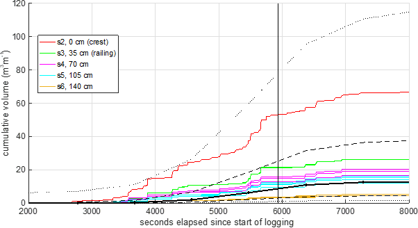
![The cumulative volume of overtopping water measured during one of the Crosby deployments. The coloured lines are measurements from WireWall, at different distances inland. The thick black line is the estimate from the Industry-standard tool Bayonet GPE (based on EurOtop) and the dashed and dotted black lines show the +/- 1 and +/- 2 standard deviations of the uncertainty in Bayonet GPE.]()
- The ability to measure overtopping in the field will ultimately reduce uncertainty in the forecasts and improve hazard warning systems.
WireWall is the first system that can measure the speed and volume of overtopping water on a wave-by-wave basis in the field. Previous field data have been obtained using large collection tanks which can only be deployed for short periods, and only obtain data on the total volume of water that has overtopped during a storm, or a high tide event. In addition, tanks can only be deployed on a few types of structures, e.g. inland of a solid wall at the top of a coastal defence, which means that the amount of data previously obtained in the field is very limited. In contrast, WireWall has been designed so that it can be deployed on almost any structure.
Until now, a lack of field data has meant that the prediction tools currently used are based on studies of a limited range of coastal defences using idealised experiments in flumes. This means that the industry standard tools that are used to predict wave overtopping have large uncertainties.
A paper just published in the Communications Engineering journal describes the validation of WireWall, and some of the results from the first trial deployments at Crosby. Validation took place in the flume facilities of our project partners at HR Wallingford. A wave machine generated waves similar to those that might be expected at Crosby, and these impacted a 1:7.5 scale model of the Crosby seawall. WireWall was deployed behind the sea wall along with traditional collection tanks to collect overtopping data. The WireWall results agreed very well with the data from the tanks. 
Following the flume tests, preliminary trial deployments of WireWall took place at Crosby, near Liverpool, in the winter of 2018/19. Eight short (single tide) deployments were made and overtopping occurred during 4 of these. Even this relatively small amount of data showed interesting results. For example, one might expect that the amount of water that came over the sea wall before high tide would be similar to the amount that overtopped after high tide, but the results showed that this was not the case: 3/4 of the water came over before high tide. With regard to hazards, the total amount of water that came over would not be classed as hazardous, even to a person walking on the promenade, but because the system measures the water from every individual wave that comes over we could show that some of the biggest waves were a hazard not just to people but to vehicles.
In future, WireWall overtopping measurements could be used to improve industry-standard overtopping prediction tools and hence improve flood and hazard forecasts. Field measurements of overtopping will also allow us to study the sort of wind and wave conditions that cause overtopping, which will improve numerical models.
The WireWall project was funded by the Natural Environment Research Council (NERC) program "Innovative Monitoring Approaches". A follow-on project Coastal REsistance: Alerts and Monitoring Technologies (CreamT) is underway, funded by NERC's Digital Environment program.
Follow on Twitter for updates: @NOCnews @Wirewall_NOC @SPFDigiEnv @NERCscience @hrwallingford